
Grip Archipelago
Back onboard and soon after we departed Kristiansund we past the old community of Grip and its attendant lighthouse.
The Grip archipelago consists of 82 islets and skerries about 14 kilometres (8.7 mi) into the Norwegian Sea northwest off Kristiansund.
The fishing village is located on Gripholmen, which is the largest and only habitable islet. The highest point is just 10 metres (33 ft) above mean sea level.
As all the turf and vegetation on Gripholmen was removed to provide clean cliffs for drying cod there was little room for agriculture. Only a few tiny gardens remained. The inhabitants could keep one or two cows grazing on the close islet Grønningen, and a few hens and pigs.
After being deserted in 1974, Grip is slowly revegetating.
After being deserted, the old houses have become popular summer houses, and in the summer Grip has 150-250 residents in 44 housing units, The harbour is still a popular dock for small fishing vessels, and the village is a popular destination for tourism in Kristiansund.
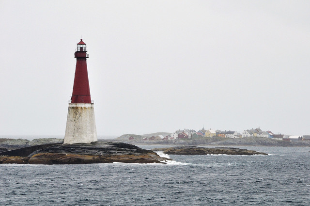
The Grip Lighthouse was built between 1885 and 1888 on the 7-metre (23 ft) high islet of Bratthårskollen, north of Gripholmen.
The 47-metre (154 ft) tall lighthouse is a red cast iron tower on a white 16-metre (52 ft) granite stonemasonry base. This is the second tallest lighthouse tower in Norway. The lighthouse's range is 19 nautical miles (35 km; 22 mi), and the white, red, or green light, depending on direction, is occulting every eight seconds.
The islet is barren rock with just the lighthouse tower, a concrete boathouse, and two wharves. The lighthouse keepers lived inside the lighthouse tower. The lighthouse was electrified in 1932, and is unmanned since it was automated in 1977
Comments
Sign in or get an account to comment.


