
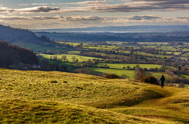
Views west of the Severn Vale and Stroud valley
It was a beautiful crisp sunny day when I went to pick up some shopping after lunchtime. I’d been feeling very tired after the long market days with very early starts which I’m not accustomed to. When I returned to the car I rather forced my self to go for a walk, and chose Selsley Common, which is on the hillside above Stroud on the Cotswold escarpment.
Once I parked on the edge of the common, I was delighted I’d made the effort. There was a light cool breeze but it was very refreshing. I walked about a quarter of a mile to the edge of the scarp where I knew there would be fine distant vistas across the River Severn Vale, the river and to the Forest of Dean foothills with the beginnings of the Welsh mountains in the distant west.
Walking across the common I heard skylarks singing and when I turned towards their songs I immediately saw two skylarks flying just twenty feet above the ground. It is the easiest I’ve ever seen them. I know they live hereabouts all year round but hearing them in this special place was a delight.
There were many walkers – some with dogs, some with children, some alone. A man was flying a huge model glider using the uplifting winds coming up the steep slopes of the scarp. High above there were actual gliders circling as they prepared to land over the woods at the Gliding Club above Woodchester Mansion. Far away over Coaley peak I could see at least five paraglider circling round and round on the same winds off the valley. A red kite climbed up from the valley bottom in small circles before eventually gliding off along the ridge of the common.
I’ve posted a Blip of the view south-west from the top of the old abandoned stone quarry, which also marks the site of ancient earthworks which are dotted all about this area. The high land to the left is the southerly escarpment along which the Cotswold Way footpath runs all the way to Bath. The river Severn flows south-west down its tidal estuary, and the final two bridging points between England and Wales are just out of sight where the M4 motorway crosses over to Chepstow.
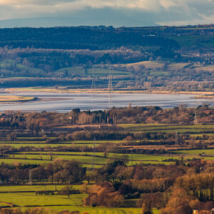
In the ‘Extras’ the first image is shot looking directly west towards the first, or last, meander of the river Severn where it curves around in a huge horseshoe shape before meeting the cliffs at Newnham-on-Severn on the far bank and turning back towards the Cotswold hills. WWT Slimbridge is sited just downstream of this picture.
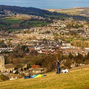
The second ‘Extra’ is a composited panorama using three pictures showing the view northward across the River Frome valley which flows through Stroud. The town centre is beyond the right of the panorama. The magnificent church in the foreground is Selsley Church and most of the valley bottom housing is post war housing development. Between me and the church a man is folding his paraglider at the end for day of dying high.
The hamlets on the hilltops are very old settlements, comprising Randwick, Ruscombe and Whiteshill. In the far distance, which the sun has illuminated, is the old wool town of Painswick nestling close to the ancient Painswick Beacon. It is the site of another Iron Age, and possibly neolithic, camp towards the head of the Painswick valley. This was formed by another stream, which has provided the means to power the mills, before flowing into the River From close to Stroud town centre
I thought these views give a good sense of the landscape around here. There are many other views as there are Five Valleys which all meet at Stroud and where the rivers coalesce to flow west to join the river Severn at Framilode about seven miles to the west, just to the north of the second photo.
Comments
Sign in or get an account to comment.


