Another day on the road.
My brain doesn't always know what to do with Canada, and especially Canadian cities. American cities are characterized by reliance on the car to get around. They have dead downtowns and low density. Simply by virtue of being a foreign country, I reflexively assume Canada to be much more enlightened. But the reality is more complicated than that. Simply put, Canadian cities struggle with much of the same issues and the same planning history that have ruined many central places in the US.
Regina is a nice enough city, fairly compact with more attention paid to its downtown than relevant US comparisons (Raleigh, N.C. was what I came up with). But there were plenty of issues that lingered. The lovely Victoria Park in the city center was begging to be surrounded by restaurants and cafes that could spill out into the street. Instead, it was all sucked into a nearby mall, where I found food and OJ at a Starbucks knockoff called Second Cup. Saskatchewan's assembly building and major cultural institutions were also quite separate from the downtown. Another big mistake and not one easily undone.
I bid Regina farewell after snacking on a truly disgusting gas station sandwich. South of the city, I picked up the thread of Canada's Route #1, which would take me all the way to Calgary. I was still musing the possibilities for urban revival in Regina when a deer bolted out of a field on the side of the highway. My brain calculated the trigonometry instantly; his speed, my speed, our possible points of contact. I gunned it, and the deer decided today was not the day to die, and cut away from the road at the last second. By the time my heart stopped beating out of my chest, I was in Moose Jaw.
Route #1 winds through some of the best/strangest named towns in the English world. Exhibit A, Moose Jaw. As I trawled Saskatchewan radio stations, I heard a good news item about the town. In Victoria B.C., to quell public anger about a new parking scheme, a business association started a marketing campaign with the slogan "Chill, you could live in Moose Jaw". The story was accompanied by a terse statement from Moose Jaw's vice-mayor and a passive aggressive sorry-not-sorry from someone responsible for the ads. It was fantastic.
Exhibit B. Medicine Hat. One of my thoughts on the road was that these town names may not be quite as bizarre as we make them out to be. Plenty of places in the US retain their original American Indian names. Plenty of these names are literal descriptions of a characteristic of the place. Perhaps names like Moose Jaw and Medicine Hat are no different than many American place names, except they've just been translated?
Either way, the road approximately between these cities is an entirely redundant area, whose purpose appears to primarily be to take up space. That's what's there anyway, space. The weather seemed equally uninspired. There was rain, but there was no passion behind it. It simply was, and I switched on my wipers and ignored it. At some point I passed into Alberta ("Wild Rose Country" — I've yet to see one) which could've happened anywhere, since the border is an arbitrary straight line anyway. You do notice the switch though, because the area on the Alberta side is occupied by a huge wheat field, and a wider-than normal dirt road. It's striking for a moment. The trans-province region appears to have been branded as the "Canadian Badlands". From the limited vantage point afforded by the highway, the area has none of the eerie landforms and topography that the real Badlands in South Dakota. Sorry Canada, you lose this round.
At some point, the weather cleared up, and it took me at least ten minutes before I remembered to turn off the wipers.
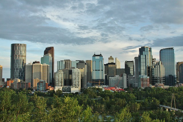
You see Calgary ("Heart of the New West" — meh) from over 20km away, just about as the outer fringes of urban area start to materialize along the sides of the highway. At that point, it's just the faraway silhouettes of the CBD though. There's a big reveal, and it comes as you drive down Centre Street. You've rolled through a few minutes of medium-density terrain, shopping plazas on either side, when you dip into a trench and are surrounded by green earthen walls. Ahead, you can see a sliver of downtown. Suddenly, the walls drop off, and you're crossing a stone bridge adorned with lions. Below, the Bow river, and ahead, the city. It's triple the size you assumed the first time you saw the skyscrapers. Before, you only were seeing the downtown in profile. Now it's a full broadside of towers and glassy condos and parks. Beautiful, my favorite city "reveals" after New York City.
Today's photo is not unique. It comes via McHugh's Bluff, which is the place where everyone who visits Calgary has taken a photo. But hell, it's a damn good place to take a photo. Cities that have a prominent hill to enjoy the skyline from get extra points in my book. Shoutout to Montreal and Oslo.
Cheers to Calgary. Looks like a fun (and diverse!) city. Can't wait to explore tomorrow.
209
views
- 0
- 0
- Canon EOS 50D
- f/10.0
- 28mm
- 1600
Comments
Sign in or get an account to comment.


