
Safe as Houses?
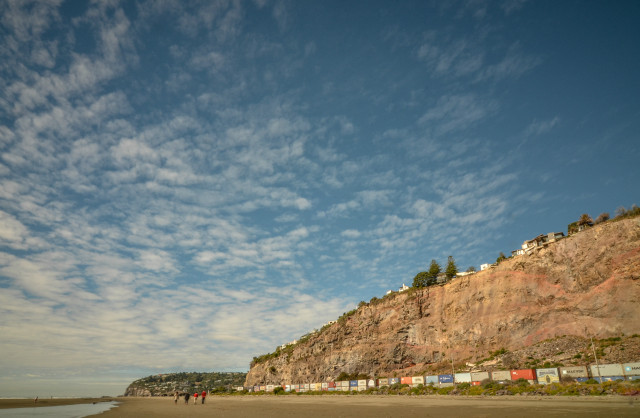
This image shows the Clifton Cliffs, towering above Sumner Beach in Christchurch NZ, with visible evidence of damage from the worst earthquakes. A great deal of 'real estate' has landed at the bottom of the cliffs, and one house in particular is half way over, and others on their way too. All of the properties along the cliff edge (all the really expensive real estate!) has been red-zoned, which means that houses are no longer allowed to be built there. They will all be demolished, along with 100s and 100s of others in Christchurch.
All of the houses on Clifton Hill have been damaged to some extent, some more than others. The February 22 2011 quake went right under my neighbours house, having travelled east - west, from Taylors Mistake. My own house is a bit of a mess, but thankfully I've been able to stay living in it, even with all the damage. I call it my crack house :-DDD - just joking. Lots of cracks, and lateral spreading - about 30 - 40mm worth. You can't see my house in this image - I'm about 200m from the cliffs - safer, and cheaper.
And the containers along the bottom of the cliffs? They're largely filled with concrete, and are there to stop damage to the traffic that travels along there, in the event of further rocking and rolling. The road goes from Sumner into Christchurch, and vice versa, and it's the only way in and out, as Evans Pass remains closed, due to heavy rockfall.
Scenic eh! I hardly notice the containers and cliff damage any more.
A lot of us out here have a little pithy sign on our cars, reading SUMNER ROCKS. You can take it whichever way you like! It hasn't rocked much for a while - long may that continue.
There are spots on this image, which I've removed in Lightroom, but although I've posted the 'cleaned' image here on Blipfoto, the spots remain! Anyone got any helpful comments?
Lens - Tokina 11-16mm f2.8 IF DX, with a 1.8 ND filter
Comments
Sign in or get an account to comment.


