
Ice Age trail!
Catching up on backblips
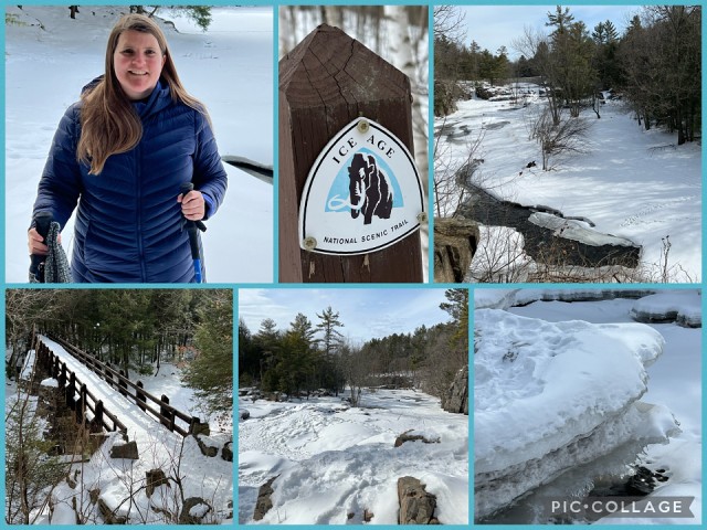
Friday March 4
Today we drove to Dells of the Eau Claire Country Park, and hiked a short section of the Ice Age National Scenic trail, which roughly follows the location of the terminal moraine from the last Ice Age. The trail passes through 30 of Wisconsin's 72 counties, from the northwestern part of the state to the Lake Michigan shoreline in the east. Along its route, the trail crosses numerous local parks, state parks and forests, state wildlife and natural areas, and the Chequamegon-Nicolet National Forest. The Dells of the Eau Claire Country Park protects a narrow rocky gorge and waterfalls where geologic processes have resulted in an unusual tilting of bedrock. “On this picturesque stretch of the Eau Claire River, the river cascades over outcrops of Precambrian-age rhyolite schist. The rhyolite schist, a very hard rock, was formed through metamorphosis and later tilted here to a nearly vertical position allowing the rock to split readily along the cleavage planes. In the dells, the river tumbles and spills across the rock’s cleavage planes while it runs smoothly in other areas where the river flows parallel to the planes.” In the winter however, this isn’t so clearly in evidence, since the river and many of the rocks are covered with snow and ice, creating a winter wonderland. Along the smoother stretches of the river, you could clearly see snowmobile tracks on the frozen, snow-covered river, but there weren’t any out today, as this last week they have begun to see some thawing, and in places there were gaps in the ice and you could see the water flowing swiftly underneath. Unfortunately, Roger and I had stupidly forgotten to pack our spikes for our hiking boots. Laura kindly let me use hers, and she and Roger managed without, using their hiking poles. For most of the hike, that was fine, as the trail was pretty flat, and went through the trees and was firmly packed snow. However at one point, the trail crossed to the other side of the river over the bridge shown in my collage. This side of the river had a few short ups and downs, and the trail received more sun, and therefore would melt a bit during the day and freeze again at night, making it a bit slick in spots. Fortunately, we all made it through safely, and returned on the original side of the river. The weather turned out to be better than forecast, and offered us some sunny spells, making for a wonderful hike - about 6 miles return.
Comments
Sign in or get an account to comment.


