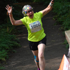
Epic!
I apologise for today's blip which will likely be of no interest to anyone other than orienteers Kiteseeker and Puffin, but I am recording it here as a reminder to me of a crazy day's orienteering.
It was great to be back in Clumber Park on a fine day, just a hint of a breeze which disappeared once we were in to the forest. We caught up with friends whilst we waited for our start times and then I was off. I took it carefully to my first control, getting used to the terrain and watching out for the crossing points we had been warned to use - no shinning over the fences! 1-2 was also pretty straightforward and I was enjoying the woodland and the exercise. Control 3 was a bit more complex with a fair bit of rough ground to cross, particularly low lying brambles which catch the ankles. I played it safe and picked up a small track which led me through the first brambly section to a wider path which I followed north westwards to another path junction, thinking I would still be quicker taking the longer path route than hacking through the rough stuff. All going according to plan, picked up the next small track through, so now I just had a short distance to the control, easy.....
I won't bore you with the next half hours except to record that it involved circling the same area several times, trying several different approaches always returning to the same rhododendrons which were my attack point for the control. All to no avail. At this point I realised that I hadn't seen any orienteers at all in this part of the forest and I started to worry. I was quite obviously in the wrong place, but then where was I?
I decided to head north in search of orienteers and eventually hit a main track at a junction but I couldn't fit it to the map! Had I gone so far that I had gone off the map? Surely not. I turned east so that at least I was heading towards the lake, which hopefully I couldn't miss and thankfully, orienteers started coming by. Taking the decision to follow them and retire I ran down the path and, at the next junction the terrain began to fall in to place.
Long story short I now knew where no.5 was, so did I continue from there and finish the course but be disqualified or try to go backwards to find the elusive no. 3? At this point I knew Tony would be wondering where I had got to, as my course was just 4.2k and I should have returned a while ago. However, I was cross with no. 3 and I wanted to know if I had been anywhere near it and how I had made the terrain fit when it obviously didn't!! So I went through in to the open area and navigated 'backwards', finding no.3 without any problems.
What should have been 4.2k turned in to 5.5 miles....
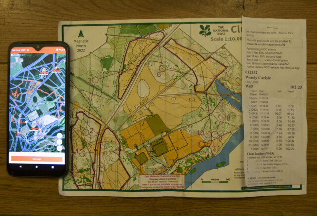
I have looked at my Garmin trace and I was very close to no.3. Tony is going to upload my route on to Route Gadget which will give folks a good laugh but will also help me reflect on what went so wrong.
It was still an excellent day out and I am glad that I didn't retire. If you have managed to stick with my description to this point then if you look closely at my splits you will see that I took 56.07 minutes to no.3 and Kiteseeker completed the whole same course in 47.30 minutes! Well done on your second place K.
Clearer on the black background.
Comments
Sign in or get an account to comment.


