Dunvegan
Dunvegan, not that you can tell from this work photo, the only image I took today.
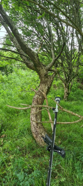
This was a long hard shift with big drives either end of the day. I had to map the position of trees numbered with tags by an arborealist on an earlier visit. I roughly followed the course they had taken, as this way the tags are encountered in numerical order. I have learned long before now that it is incredibly easy to miss a tree or measure the same one twice and use some tricks in the controller software to trap such blunders. That is the reason for my deliberations here. Prior to this I had mapped 560, 561, 562, 563, 564, (you get the idea) but the next tags nearby jumped to 566, 567. I concluded this plant was plausibly 565 and hunted about the forest floor looking for the lost tag for some corroboration. I couldn't reach anyone on the phone to ask the question.
Measuring tree trunks in dense forest cannot be done by GPS (fast) and I must use a total station. This is limited by line of sight and for the measurement to take place the robotic TS must acquire "lock" on the prism on top of the pole. With low hanging branches and other scrub every measurement required a tedious search to re-acquire lock but often it failed, and I had to run back to the car for a saw to do some localised pruning to accommodate line of sight.
This is a survey task which benefits from a two operator team but I have not recruited anyone yet.
Comments
Sign in or get an account to comment.


