
Groningen City Boundary Markers - Book A
This is the seventh blip in the Groningen City Boundary Markers series. Previous entries:
Book C
Book R
Book U
Book O
Book N
Book G
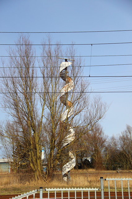
This particular marker is not reachable because it is located between two railroad tracks; both visible in this shot. On Google maps it seems the road continues all the way up to the marker, but you can see the gate in the foreground that makes it very explicit that you should not cross the railroad tracks...
I then tried reaching the marker from the other side but was stopped by a gate. I felt very much like a criminal when I managed to bypass the gate by crossing a ditch. With one very wet and dirty shoe and muddy jeans I continued, only to be stopped by a second gate... This shot was taken at that gate. On the way back to the car I noticed my hand was bleeding; no clue when that happened. So, when I returned home it looked like I escaped from prison and that's what it felt like too.
This map shows the location of all the boundary markers (see below for explanation of the letters assigned to the markers). There appears to be no sign next to the marker, but from the previous blips and some research on the internet it would seem that the sign should read:
For centuries, town borders were marked by walls and fortifications interspersed with highly decorated gates. The gates gave the outside world access to the towns and opened them up to the surrounding countryside. Many of the old walls and gates were pulled down in the 19th century, when towns lost their traditional shape. Groningen received the town charter in 1040. As part of the celebrations to mark is 950th anniversary, it was decided to erect a series of markers indicating the boundaries of the city and spelling its ancient name CRUONINGA. The project has been designed by Daniel Libeskind.
The observatory designed by Leonhard Lapin with Enn Laansoo looks like an ivory tower from the outside. The staircase ends in a mirror: the gate at the border between reality and irreality. Climbing to the top, we rise above the earth from where we can read the book of the universe.
One more thing: the original idea for this marker was for the steps of the staircase to start all the way at the bottom. Because of its location near the tracks and to avoid people committing suicide from this, the steps start at a height of three meters.
Comments
Sign in or get an account to comment.


