Death Valley
My son and I set off at 8am this morning complete with picnic, walking boots, sunglasses, cameras (of course) and heavy fleeces, hats and gloves. We were off to Death Valley in California - a 370 mile round trip. It was a very cold 0' when we started but the sky was clear and the sun was starting to warm up; it was a keen wind which kept things cool.
We journeyed north through the Amargosa Desert until we reached a country township of Beatty where we turned off for a quick recce at a ghost town called Rhyolite which was established in 1904 after two prospectors found gold on a nearby hill. The panic of 1907 dealt a cruel blow and by 1910 the population had shrunk from about 10,000 to a few dozen. Only a few interesting ruins now remain midst the picturesque hills.
We continued on, soon turning onto a 30 mile stretch of stony unmade road which led us into Titus Canyon where we climbed through magnificent hills to 5,250 feet., during which time we had passed from Nevada into California. Some of the hills were a superb mix of pinky tones and some of sandstone. Eventually we dropped down through the canyon until we came to the final couple of miles where we found ourselves winding through a really breathtaking, narrow gorge where you could see how the river had once, many moons ago, burled and thrashed its way down carving out a tortuous channel through the hills. Then suddenly we blinked and we were out, with the vastness of Death Valley lying before us. We stopped for our picnic and were down to t shirts with temperatures well into the high 60's and with a clear blue sky, sun and no wind.
The 3.4 million acres of Death Valley are the driest, hottest and lowest in the USA but along the sides of this long, wide and fairly flat valley are also high mountain ridges where the highest mountain is just over 11,000 feet. We had entered the valley about half way through and turned back southwards to enjoy the various rock formations, sand dunes and most interestingly, when we dropped down to 250 feet below sea level, a vast expanse of salt flats at a place called Badwater. We stopped to take photos of the amazing encrusted salt layers but were also keeping an eye on the sun because we wanted to be able to watch the sunset from Dantes Peak, which involved a fairly long drive up into one of the ridges which flanked the valley.
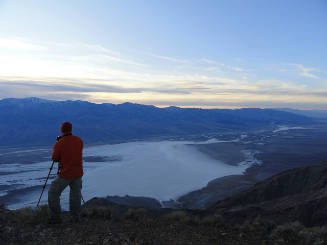
It was quite exciting as the road took us higher and higher in twists and turns because we kept watching the sun sink lower and lower in the sky and weren't entirely sure if we would be there in time. However my trusty driver managed just fine and we arrived at the car park to complete the last bit on foot, reaching the 5,500 foot peak in time for my son to be able to set up his camera and tripod before the sun set. The view was simply stunning as you can see from my blip. Looking northwards you can see the flat valley with the mountain ridges on both sides. The huge whitish area immediately below us is not a lake but the huge salt flats from were we had made our sprint to Dantes Peak. It was very, very cold at the top but we remained there taking lots of pictures, although my battery died soon after my blipped capture, until the red glow of the sun finally disappeared behind the mountains at about 5 o'cock. By the time we returned to the car we were frozen but had luckily kept a couple of our own mince pies back from the picnic. These were made yesterday using a homemade cranberry mincemeat as we couldn't source miincemeat here.
We eventually reached home at 7:30pm where my daughter-in-law had spent a busy day in peace and quiet preparing for Christmas. Yet another unique and fabulous day.
I didn't manage to post anything yesterday, or comment I'm afraid, but have backblipped if anyone is interested.
307
views
- 2
- 2
- Sony DSC-H55
- f/3.5
- 4mm
Comments
Sign in or get an account to comment.


