
Rodborough and Stroud from Claypits Lane
I didn't have much time today for photography as there was an important meeting to attend at Ebley Mill, to sort out some Neighbourhood Plan issues that had arisen.
I went to get some vegetable supplies at the Stancombe Beech farm shop in Bisley at lunchtime, but I didn't have time to chat as I usually do. I also stocked up with a 13 kg bag of sunflower hearts for the birds to eat from our hanging feeders over the next month or so.
On the way back down the hill into Stroud, I diverted off the old road back to Stroud at Lypiatt and took a different single lane road along the course of an old droving trackdown through Middle Lypiatt and then Nether Lypiatt. I thought that I might be able to grab a landscape view from the top of the Cotswold escarpment looking westwards down over the junction of the Five Valleys which is where Stroud town is situated.
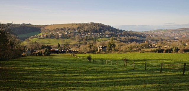
I pulled into the sire of the old claypit quarry on Claypits Lane just above the hamlet of Thrupp, where the ancient woodland becomes pasture. I can see the spot from here at my desk on the far side of the Lime Brook valley which runs at right angles down to meet the River Frome valley, which this picture is showing. I love these old fields and the small settlements situated along the spring line between the clays and Cotswold limestone strata. You can see the settlement of Rodborough where it meets Bagpath directly opposite halfway up the hillside.
At the bottom of the field I was standing in is Thrupp farm and a similar line of houses spreads along the spring line at about the same height on this side of the Golden Valley. If you look carefully, and possibly using the 'large' view, you can see the marking of old field boundaries and a hollow way in the pastures on the far side. To the right of where I am standing is Ferney Close as marked on the 1842 Tithe Map of the area, and a bout two hundred yards to my right is where my friend Neil, an archaeologist has found a lot of Roman artefacts indicating that there was some form of settlement there below a waterfall of the stream running down to merge with the Lime Brook.
On the top of the hillside opposite in this picture is Rodborough Common, where I blipped the Redwing yesterday. On the far right is the urban area of Stroud Town, and between where I am standing and the town centre is the Trinity parish ward, which I was elected to represent. I am mulling over whether to stand again next spring, as it takes a lot of my time and energy. We shall see.
Comments
Sign in or get an account to comment.


