
Erith Pier - Now and Then
BOBOROID has been posting "Now and Then" images recently which I find fascinating. So today I decided to try my hand at one for myself.
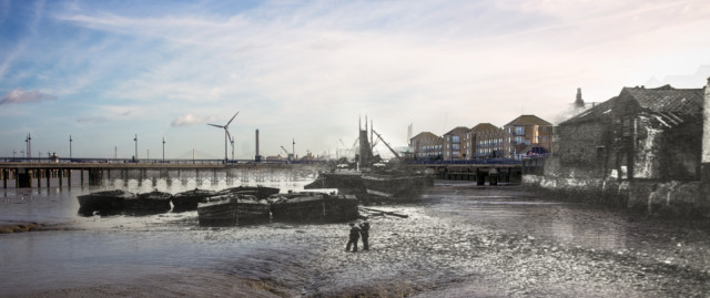
Erith is just a few mile from my Mum's on the River Thames, and finding an old photo in a book of published by the local library, probably from around 1910, set out to get a modern version.
The history of Erith is inextricably bound up with the river, and Henry VIII located part of his naval dockyard just behind the point where these photos were taken. During the 19th century the area became a major industrial centre, particularly from the Victorian period when entrepreneurs such as William Anderson and Charles Beadle made the town one of the most important industrial areas in the south-east of England. Engineering was the prominent industry, with armaments and cable production to the fore. Vickers was an important employer in the town and was linked to the Royal Arsenal at nearby Woolwich, where my Grandfather worked.
Today, this heritage has all but disappeared, and the Riverside houses have been demolished. They have replaced by modern apartment buildings and a new water front, marking the start of the Thames Path Extension from Erith to the Thames Barrier at Woolwich, where it joins up with the Thames Path National Trail footpath running for 180 miles along the banks of the river Thames to Kemble in Gloucestershire.
Erith's name dates from Saxon times and means muddy harbour or gravelly landing place. Today's photo, taken at low tide, shows the former, with mud banks and deep water channels. The boys walking on the gravelly beach in the earlier photo would be knee deep in mud today. One wonders what they would had thought about the giant windmill.
Comments
Sign in or get an account to comment.


