Between new and old towns: Princes Street Gardens
See reverse views taken in 2012.
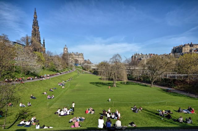
(MAIN PHOTO)
Six hundred years ago the land now occupied by these public gardens was a marsh which comprised part of the northern defences of the town of Edinburgh. In 1460 the Scottish King James III ordered the marsh to be dammed and flooded, to strengthen the town defences. The former marsh then became known as the Nor' Loch, or Northern Lake.
The population of the old town (to the right in this photo) grew, and its detritus cast into the Nor'Loch caused an ever increasing degree of pollution.
In 1763 the loch was drained, to enable the construction of the North Bridge - just discernable in this photo at rear, look for the white tops of two buses - to connect the Old Town and Calton Hill. This work was also related to the initial stages of building Edinburgh's New Town.
The garden layout is simple, it provides a haven of peace (and occasional sunshine) in the very heart of today's city. Just to its right , occupying the south-easternmost part of the former Nor' Loch, is Waverley Station.
The rocket-shaped Gothic monument, which stands on the South side of Prince's Street, is a memorial to the fine Scottish writer Sir Walter Scott. (You need to climb just 287 steps to get to its highest viewpoint. I must find the time to experience this on my next visit ... weather permitting, of course.)
(EXTRA PHOTO)
This view, taken from Edinburgh's Mound, looks north eastwards towards the Princes Street Gardens and Scott Monument. In the foreground is Scotland's National (Picture) Gallery in Greek style.
On the horizon at left of photo you can see the Firth of Forth, the Kingdom of Fife and one of the two Lomond Hills.
151
views
- 3
- 0
- Nikon D7000
- 1/1250
- f/10.0
- 14mm
- 800
Comments
Sign in or get an account to comment.


