
Park Howard Llanelli
PH012PH018
07/12 start stop bwd fwd
Parc Howard lies on the northern outskirts of the town of Llanelli immediately to the west, and just off, the A476 road from Crosshands, at about 42 metres AOD. Before the town sprawled up to meet it, there would have been fine views of the surrounding countryside, the Loughor estuary and probably the sea from Parc Howard.
In the early nineteenth century the property, which was then known as Bryncaerau park/mansion/castle, (all three appear in documents), was the home of Mr R.T. Howell, a well known business man and Harbour Commissioner. Upon his death, the house passed to the architect James Buckley Wilson, who was a grandson of the Revd James Buckley. It was James Buckley Wilson who designed the alterations and extensions which transformed the building into the Italianate mansion of today. Comparison between the First and Second editions of the 25 inch surveys, 1878 and 1905 respectively, shows that the alterations to the ground plan were considerable. The entrance was altered from the south-west face to the south-east and a porte cochère was added to accommodate the new drive. The wing to the north-west was extended and the out buildings to the north-east were re-configured; there were also substantial changes in the layout of the garden. James Buckley Wilson was justifiably proud of Bryncaerau and included it in his application to be admitted a fellow of the Royal Institute of British Architects.
In 1911, the mansion was sold by Mr J.F.H. Buckley to Sir Stafford Howard, for £7,750. Sir Stafford bought the house and grounds with the intent to gift them to the people of Llanelli to celebrate his marriage of the previous September. In January 1912, Sir Stafford and Lady Howard Stepney presented the mansion to the town, granting to the Council a 999 year lease for the rent of 5 shillings. As a condition of this gift, Sir Stafford required that the Council complete the transformation of the grounds into a public park within 8 months. There were two reasons for this condition; firstly, he wished the transformation to be complete and the gardens open on the first anniversary of his wedding. Secondly, he had a belief that local authorities were inclined to be somewhat slow, and this was a way of enforcing progress.
The work, which cost £4,500, would not have been completed but for an industrial dispute. The miner's strike in March 1912 had put thousands of men out of work, so the Council was able to employ additional labour, thus ensuring that all would be ready for the September deadline. On Saturday 21 September 1912, the grounds and the mansion were opened by Lady Howard Stepney on her first wedding anniversary. In 1915 the mansion was converted into a hospital for wounded soldiers, with 40 soldiers occupying the 5 wards being attended to by 18 Red Cross nurses. In 1921 the mansion was let to the War Pensions Committee for a further 3 years. In 1965, the Borough Council completed the purchase of the Stepney estate for £350,000; this included Parc Howard and the surrounding 32 acres.
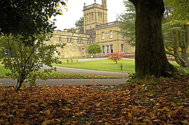
The Italianate mansion, which is of two storeys, faces south-east, and is clad with dressed Bath stone, with a port-cochère in the front centre. To either side of the central block are two small symmetrical extensions; on all the corners the quoins stand proud. The building is topped with a balustraded parapet with urns at the corners. Set almost centrally is a small tower, again with balustraded parapet and urns. To the rear, (northwest) were the stable and carriage blocks and service areas, which are now used as Council stores. To the front (south-east) are two sets of steps that appear to be contemporary, leading to the lawns and gardens. There are no other contemporary buildings within the grounds. The lodge that was to the south-east of the house has now been demolished.
The park now occupies an area of just over 24 acres to the north of the town of Llanelli. The geology and topography of the area has dictated the current land use of the park. To the north-east, south-east and south west of the house, the land is now gently sloping, being flattened in areas to allow for amenity uses. To the north and north-west of the house is an escarpment, behind which the land drops towards the marshy land fronting Pentreporth road. The flatter land is maintained to municipal standards, whilst the land to the north is more informal and there are kick-about areas.
Comparison between three 25 inch Ordnance Survey maps indicate the extent to which the gardens have changed. The surveys chosen were 1878, prior to the re-modelling of the house, the 1905 revision and a survey published in the mid 1960's. The earliest shows a formal enclosed rectangle with one main entrance to the south-west at SN 5087 0108. From here the drive ran mostly parallel to the south-western boundary until it reached the front (south-west) of the house. To the south-east of the house (now the front, but then the side), the somewhat formal gardens could be enjoyed from the paths that created a double U pattern. To the north of these gardens was a sun-dial, whilst to the south was a fountain and small U-shaped pond. To the north-west of the house (now the rear) were two more formal enclosed areas, the larger one, to the west, contained a glass house and probably a pergola that was approximately 8 metres long, running parallel to the southern wall.
By 1905 the gardens had become considerably more informal, less geometric, in their design. The area enclosed had been enlarged by nearly two acres and the new perimeter boundaries were curved and flowing. The formality and rigidity within the gardens also appears to have been swept away. Because the house front has now been moved to the south-east, the drive curves to this front from where it continues as a path in a semicircle so that it re-joins the drive just before the entrance. Only one other path is shown. The formal pond has been extended and now echoes the curves of the drive, this feature now being referred to as a fish pond. To the rear (south-west) of the house, the two enclosed gardens have also vanished, instead are extensive areas of glass and outbuildings.
During the 1930s, the Council was able to acquire more land, so that the park extended a further 5 acres to the north-east as far as the newly formed Parc Howard Avenue. A new entrance was made from Felin Foel Road and a perimeter path constructed around the new area.
The amount of time and labour required to undertake the initial landscaping work of 1912 suggests that these gardens were altered considerably over that period. Mapped evidence indicates that the many paths were laid out, as were the small sunken gardens to the south of the park. The bandstand and tennis courts were probably also part of these schemes. The lodge vanished some time between 1905 and the 1960's.
Today the park is very much as it appeared in the 1970s. There is an informal lawn of some 5.2 acres to the north-west of the house. A small, slightly formal grassed terrace to the front of the house, which is retained by a low stone wall and reached via two sets of steps to the north and two to the south. A pond area to the south of this lawn, which seems to be reserved for exotic water-fowl and there is a paved, sunken garden to the west of the pond. The octagonal bandstand is to the north-west of the sunken garden, has been recently restored.
To the west of the house are the bowling greens and tennis courts and adjacent there is a childre n s play area.
The council now want to privatise it for the developed to turn this old Mansion into a wedding/ events venue, that will mean tearing up the playing field / gardens to make a car park!..
Ordnance Survey, 25 inch, (c. 1970).
70
views
- 0
- 0
Comments
Sign in or get an account to comment.


