
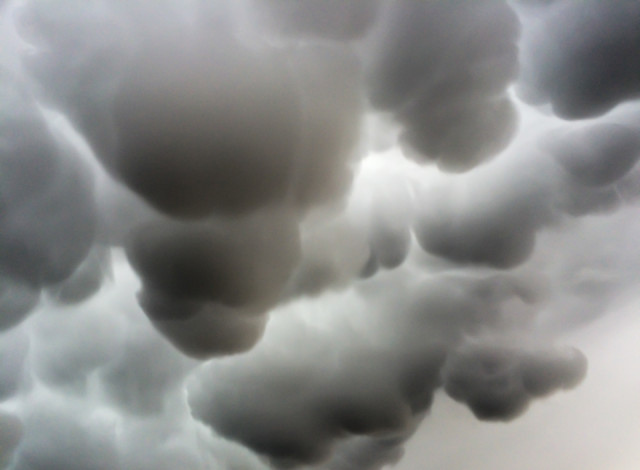
Mammatus clouds
I left to collect Ben shortly after a tremendous hailstorm, and as I drove down Thorpe Road I was amazed to see that the sky was filled with these amazing mammatus clouds. I cursed that I only had my iPhone (and not enough time to return home to get a proper camera), but stopped at the first opportunity to capture this unusual phenomenon.
Mammatus, also known as mammatocumulus (meaning "mammary cloud") is a meteorological term applied to a cellular pattern of pouches hanging underneath the base of a cloud. The name mammatus is derived from the Latin mamma (meaning "udder" or "breast"). Mammatus are most often associated with anvil clouds and also severe thunderstorms.
Mammatus may appear as smooth, ragged or lumpy lobes and may be opaque or translucent. Because mammatus occur as a grouping of lobes, the way they clump together can vary from an isolated cluster to a field of mammae that spread over hundreds of kilometers to being organized along a line, and may be composed of unequal or similarly-sized lobes. The individual mammatus lobe average diameters of 1–3 km and lengths on average of 0.5 km. A lobe can last an average of 10 minutes, but a whole cluster of mamma can range from 15 minutes to a few hours. They are usually composed of ice, but also can be a mixture of ice and liquid water or be composed of almost entirely liquid water.
True to their ominous appearance, mammatus clouds are often harbingers of a coming storm or other extreme weather system. They can extend for hundreds of miles in each direction and individual formations can remain visibly static for ten to fifteen minutes at a time. While they may appear foreboding they are merely the messengers - appearing around, before or even after severe weather.
This particular formation was visible for about twenty-five minutes, but unfortunately just about dispersed by the time Ben got out of college, so he never quite saw it.
383
views
- 19
- 4
- Apple iPhone 5s
- 1/345
- f/2.2
- 4mm
- 32
Comments
Sign in or get an account to comment.


