Of Horse Thieves and Petroglyphs
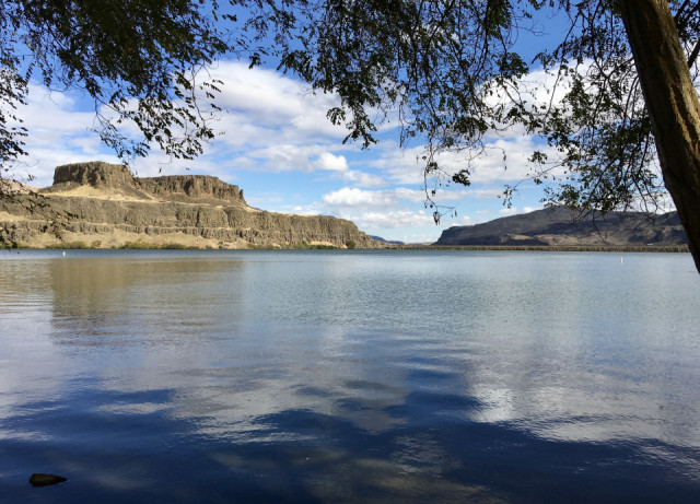
This is the view east from Horsethief Lake along the Columbia River. You can see on the basalt cliffs the stratigraphy or various lava layers rising up the cliffs. Each of these layers represents a different lava flow, some hundreds of feet thick in places. As I've described in earlier blips, these lava flows are part of the Missoula Floods that occurred about 12,000 years ago.
How The Lake Was Named
"Oral history states that the park received its name -- Horsethief Lake State Park -- from workers in the U.S. Army Corps of Engineers who developed the site. The workers thought the terrain was similar to that of horse thief hideouts in popular 1950s Hollywood westerns. The abundance of horses kept on the premises by local Indians apparently gave the workers their inspiration."
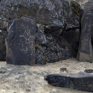
The Extra Photo: Petroglyphs
Some of the oldest pictographs in the Northwest are found in this park. In 1957 when The Dalles Dam was completed and the waters of Lake Celilo were rising, the U.S. Government removed a few ancient Indian petroglyphs from the walls of a canyon downstream of Celilo. This canyon carried the Indian name of "Tamani Pesh-Wa" or "Written on the Rock". Locals called it "Petroglyph Canyon".
In 2003 the U.S. Army Corps of Engineers cleaned and restored the petroglyphs and moved them to the then-called Horsethief Lake State Park, now called Columbia Hills State Park. Today the collection of over 40 Petroglyphs and Pictographs is bordered by a paved trail for easy public viewing, and is less than a mile from the flooded Petroglyph Canyon. More petroglyphs and pictographs, including"Tsagaglalal" ("She Who Watches") can be seen nearby when guided walks are being led. (http://columbiariverimages.com/Regions/Places/horsethief_butte.html)
Thank you all for you comments, stars and hearts for yesterday's blip about the Coyote Chase. I appreciate hearing from you and enjoy reading your thoughts.
Comments
Sign in or get an account to comment.


