
How the lie of the land looked in 1919
It was back to 'business' today, culminating in a full Town Council meeting this evening. I felt it was very productive, with some big issues being discussed, and we had good support from other local councillors from both the District and County Council reporting on the issues relating to all three councils. I have just got home at 10pm and have to prepare for two further town council related meetings tomorrow morning.
This morning I finally completed a task I had been putting off for too long. I had borrowed a document from a friend, which I've wanted to photograph as it is very rare and contains very interesting historical information. So I set up my tripod in the cabin and made digital recordings of about 60 pages of the sale prospectus of Lypiatt Park Estate, which was auctioned in hundreds of lots in 1919. The lots described land, houses, farms, woodlands, outbuildings and described them all in some detail.
I was lent the brochure by A., who is a farmer on some of the land that was up for sale from which he and his family run the Stancombe Beech Farm Shop in Bisley. He was brought up on the estate in the 1960s after it had passed into the hands of the noted sculptor Lynn Chadwick, whose family still own the main house and its massive gardens.
I then went to drop off the brochure at the Farm Shop and met a woman who lived in a farm which was also one of the properties originally owned by the Dorrington family back in 1919. She said her husband has some more old documents relating to the local landscape history and who always likes to chat about such things. So I hope to meet up with him in due course.
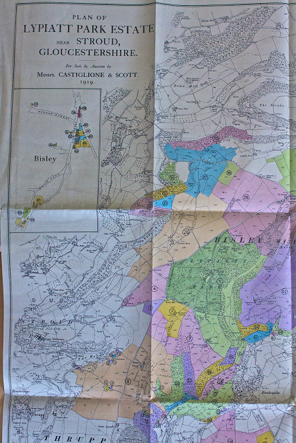
This picture is of part of the map of the estate showing all the lots in different colours superimposed on the ordnance survey map of the time. It is fascinating as it shows the land at the end of the Victorian era, just when so much change was about to occur to the land and its usage, after centuries of very slow change.
The coloured areas shown here are only about half of the total area owned by the Lypiatt Park Estate at the time, all I could fit in to the frame. The green area marks the current area of Lypiatt Park, where the mansion overlooks the upper reaches of the Toadsmoor valley that was formed by springs flowing out just below the church in the ancient village of Bisley.
Regular visitors to this journal will have heard me going on about my interest in The Horns valley in which we live and seen many of the views. That valley is shown at the bottom left of the photo, just to the north of Bowbridge and Thrupp with the eastern edge of Stroud at that bottom left. I have noticed that, as a councillor,one of my ward resident's houses, called Snakeshole, is marked as being one of the properties that was sold as a result of this prospectus. It marks the furthest edge of the Town's parish boundary. I wonder if the current resident voted for me?
Comments
Sign in or get an account to comment.


