
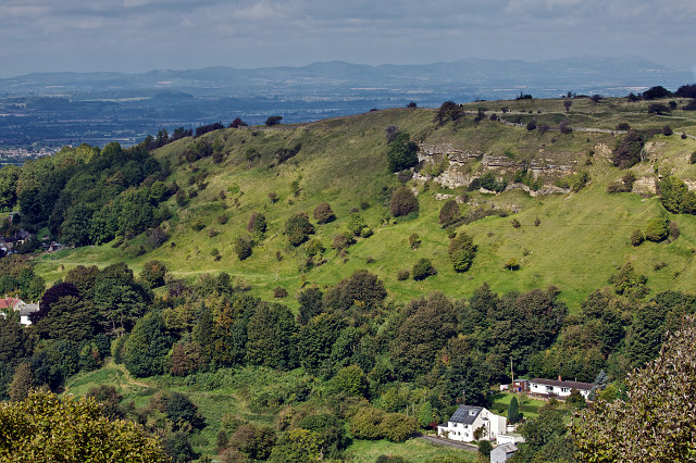
Crickley Hill from Barrow Wake viewpoint
We needed some supplies from the farm shop in Bisley, so I sensed a photo opportunity since the sun was shining and the wind was still. I drove on to the hamlet of Througham, set back from the road from Bisley to Cheltenham, but the views I had in mind were rather dull. So I carried on a further couple of miles to do a recce of some ancient woodlands near Birdlip, which I love to visit.
After parking, I took my rather heavy tripod and looked for some wide vistas through the beech trees, but I'd forgotten that the views develop under the canopy when the leaves fall, which still seems some far away. In fact there were hardly any golden beech leaves at all. By the time I had set up my equipment, there was no longer any sun breaking through to the now gloomy floor of the wood, and a complete cloud cover soon brought rain in increasingly heavy amounts. So I returned home where I did photograph a nuthatch feeding near to the house, but they were all very dark and by the time I had processed them they looked rather grainy and more like a pastel painting.
So I've resorted to a landscape shot I took on the way to the woodlands, at a notorious viewpoint. It is sited close to an ancient footpath, which has been re-named as the Cotswold Way, which is a modern tourist route along the line of the Cotswold escarpment. This particular spot is called Barrow Wake, and is quite close to the old Roman road from Cirencester to Gloucester. The modern A40 road also follows a similar route and was re-aligned to join another old road to form a junction at the Air Balloon pub, where the road drops down a deep valley to sweep onto the Severn Vale below.
That road lies just in front of the white house at the bottom right of the picture, below the outcrop of Crickley Hill above it. Limestone rocks form cliffs there which allowed neolithic peoples to build a big safe encampment on the hill above, with the obvious far reaching views across the Severn to the Forest of Dean and the Malvern Hills which form the famous serpent's back that you can see in the distance towards the north-west.
At the view-point there are plaques which explain what you can see, with a description of the geology and some local history. There is a lot of landslip but in principle the Inferior Oolite limestone lies above first the Pea Grit, the Sands, the Upper Lias Clays, Marlstone and then the Middle Lias Sands and Clays that predominate in the Severn Vale, along with glacial deposits brought down from the north in former Ice Ages.
The Birdlip Mirror at Barrow Wake: (This is part of what is written on the plaque at the viewpoint. A replica of the decorated back of the mirror is also etched onto this metal plaque .)
In 1879, a workman extracting stone from a quarry situated somewhere behind you, uncovered three skeletons lying in a rough, stone-lined tomb. The central remains were those of a woman around 35 years of age. Accompanying her were several objects, the most important of which was a beautiful bronze mirror. The front was originally polished to a mirror finish for reflection, while the back was decorated with flowing patterns carefully engraved in the metal. The mirror is one of the finest examples of of British Celtic art to survive. It may be viewed at Gloucester City Museum along with the other finds including a silver brooch, bronze bowls and a necklace of amber, shale and marble beads.
The exposed cliffs of Crickley Hill show how the oolitic limestone has been laid down in layers. A perticular form of limestone made up of pea-like nodules is found here, known as pea-grit and these cliffs show the finest outcrop in the country. However it is of no use as a building stone due to its crumbly nature.
Crickley Hill Country Park can be seen on the other side of the valley set on a spur of the Cotswold escarpment. It was established as a country park in 1979 . From this viewpoint you can see the remains of a 2,500 years old defensive wall built of stone interlaced with wooden beams. Originally it was over 5 metres high and had a walkway along the top. It defended an Iron Age village of thatched round houses built on the flat part of the hill to the left of the wall. Archaeologists think that this village was destroyed and the wall burnt around 500 BC.
Comments
Sign in or get an account to comment.


