River and Railway
River Petterill
(Part 14)
When we left the River Petterill, as it flowed past Newton Reigny, I mentioned that it turned north at this point and headed for Carlisle. In the meantime I have been describing how an outlet from the Petterill, Thacka Beck, was created. Now we are back with the main river and will be following its journey to Carlisle.
The interesting thing is that the valley of the River Petterill has been used over the centuries for different north south transport links – an important Roman Road followed it, the A6, which used much of the Roman Road route follows it, the Lancaster and Carlisle Railway (now the West Coast) follows it and the M6 motorway also takes the same route. Sometimes they are very close together and occasionally they share the same road bridges.
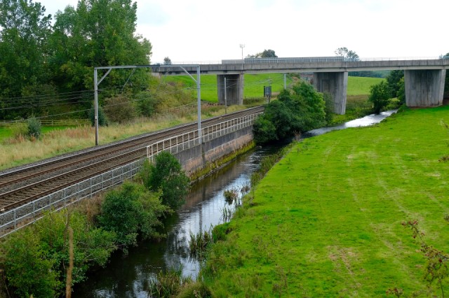
It is particularly interesting to see how closely the railway follows the Petterill, as they both head for Carlisle from Penrith. The Lancaster & Carlisle Railway was opened in 1846. It became part of the London & North Western Railway and is now part of the West Coast Main Line. The Petterill and the railway first meet just north of Penrith at the point pictured here. The bridge in the photo carries the road that links the A6 with the M6 and was built at the same time.
You can see how the railway engineers have built up the bank of the river, almost canalising it. We think that this was possibly thought to be a cheaper option than creating embankments through the hills on each side of the river here. The river looks to be quite narrow, but that is the effect of the building. At the other side of the bridge I am standing on (a much more interesting one that the utilitarian one in the picture) the river spreads out again and creates quite a wide flood plain.
Comments
Sign in or get an account to comment.


