Correpoco
Fieldtrip #2 with Juan Carlos - this time on a 4th year course about Natural Hazards.
Meeting at 9, but wasn't sure if I'd make it. Had been feeling a bit worse for wear over breakfast, and the last thing that I wanted was to spend hours on a bus worrying if I was going to have to jump off or greatly embarrass myself. Not fun. So walked very slowly to the bus, until I was sure that all was safe, and said hi to the crew.
Arminel was also ill - so I was the only English, and one of 2 ERASMUS, so the whole day was in Spanish, which is always nice. Because we didn't have 'proper' uni today, we'd both gone out to the pub, and so we were sleeping on the bus at every opportunity. Even the obligatory mid-morning coffee break didn't help - I swear it made me more tired!
This said, it was an amazingly interesting trip - looking at more pure natural hazards such as landslips, to more human created ones. We first visited a leaning tower of flats - with an angle of about 15 degrees, which had made the national news in Spain. This block of flats had been built on reclaimed land (much of the bay of Santander is reclaimed for industry and ports), and had insufficient foundations. In my mind this would be a purely human hazards - it's human stupidity to build on such soft land without good foundations - but hey. We visited a road nearby that had the same problems - it had been deformed into waves by passing traffic, a result of the material used to infill the land.
Next, we went to Polanco, near the factory Solvay. Since 1867 Solcay has been extracting salt from the ground near Polanco, to be used to make carbonate soda. This extraction process - pumping hot water under pressure into the clay 300 or so meters deep, then extracting the salty solution - has left vacuous areas deep in the ground, and has lead to huge subsidence and appearance of pot-holes the size of towns. If you click here you can see the satellite images, showing the pot-holes and the access tracks to new ones.
We then looked at the river management at various towns, which was limited to canalisation - before moving up the river valley to see how river channels move about flood plains. Was awesome to see the old river banks so clearly on dry land, and interesting to see how all the old villages were well away from any old channel on higher land, where as new developments had been build in the middle of old channels, where a channel could re-open after a flood or surge.
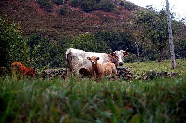
The most impressive natural hazard was a Correpoco, where the photo was taken. This is a huge area of land that is slowly slipping into the valley below, after a road cutting set the slop in motion. Already half the church has gone down the slope, along with a house and lots of gardens - and it's getting faster. It's possible that it could all go any minute, following minor seismic activity or very heavy rainfall. These cows wouldn't know what had hit them... but the village is all too aware of the danger.
Back home at 7, and a rushed decision to go to a club at the Bilbao Guggenheim - 'art after dark'. Should be fun.
Comments
Sign in or get an account to comment.


