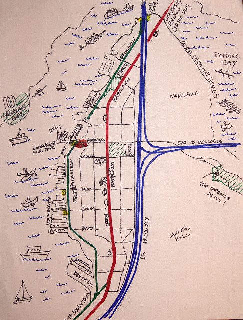
My Two Streets
I am very fond of maps. This may evolve and change, but I tried to make a simple version of where I live and the 2 streets I'm blipping (from time to time) for the One Street project that Kendall started.
North is up.
This is the Eastlake Neighborhood in Seattle, one of the most defined neighborhoods in the city thanks to the 1962 freeway (blue) that cut this area in half. Blue lines, goes north to Vancouver B. C and south to Portland OR. Cuts off to Bellevue.
People began living here in the 1890's
The University Bridge (on top) was built in 1919.
We live in a 9 unit townhouse condo at Roanoke and Fairview (the red blob) We can walk to the UW to a class or lecture in 35 minutes.
The Red line is Eastlake, the corridor between the UW and downtown -it's maybe for us, a 50 minute walk downtown. Buses, traffic, lots of businesses and restaurants. (but NO grocery, drug or hardware store!!)
The Green line along the lake is Fairview, more of that country feel. - hardly any sidewalks, many lake related businesses (NOAA just vacated their spot) - all the little projections are mostly houseboat docks.\ with maybe a dozen or more floating homes.
I tried to draw a little Coffee cup for the coffee shops nearby!! (whoch I eventually will probably blip...
The parks have green stripes.
So you can see it's not many streets (actually Eastlake extends a few blocks farther south, but I'm not going there..) there's way too much history to relate. If you want to know more, go HERE. (That's my wee logo on the top...which shows what Eastlake is all about-from the lake.)
Comments
Sign in or get an account to comment.


