Deep mapping
A project has commenced to create a digital map of one particular small area of North Pembrokeshire: the coastal promontory called Garn Fawr and the bay below, Pwll Deri.
The map will not be simply a graphic representation of what is on the ground. It's to be a 'deep map' gathering information about local history, natural history and family history, geology, language, traditions, legends, and reminiscences, photographs and documents, and the art, music, stories and poetry the place inspires, and including people's personal experiences, impressions and responses to the place. A deep map consists of multiple layers woven together, horizontally and vertically, to create something much more rich and inclusive than conventional cartography. It's not static but reaches back and forward in time. It's both a narrative and a journey.
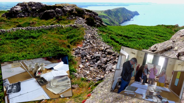
Central to the idea of deep mapping is the equal contribution of experts, visitors and inhabitants, along with existing records both public and private.. We perused some of these, spread out on tables in a local village hall (bills, wills, tenancy agreements, newspaper cuttings, genealogies) and chatted to local people whose history they contained. Volunteers with technical know-how pondered how best to digitalize all the information and create a database that will be accessible to all. Experts were on hand to advise on their particular branch of knowledge. Schoolchildren had visited the hill fort a few days earlier, with a local poet, to make poems there in Welsh and English. The wild life was being studied and recorded. Everyone was encouraged to participate, collect and contribute. New material is no less important than old.
My composite blip shows part of Garn Fawr's Iron Age fortification with the remains of an defensive rampart, viewed from the World War One coastal lookout post. A WW2 U boat monitoring station was located nearby. On the southern slope the artist John Piper lived and painted. Welsh poet Dewi Emrys is commemorated above the cliffs. In the bay below (Pwll Deri) seals wallow, birds swoop and waves ripple. Inland the surrounding fields are dotted with toy tractors and tiny cows.
The two inserted images show local memorabilia being examined and discussed.
It's just the beginning but it's already very exciting.
Something about deep mapping
Comments
Sign in or get an account to comment.


