
#1 of 'A history in 50 images'
At the end of last year I decided that I'd try to produce a history of the parish in 50 images, one per week in roughly chronological order. So here's the first of the 50. It was quite difficult to decide where to start but I've chosen this image to represent the earliest known occupation of the area.
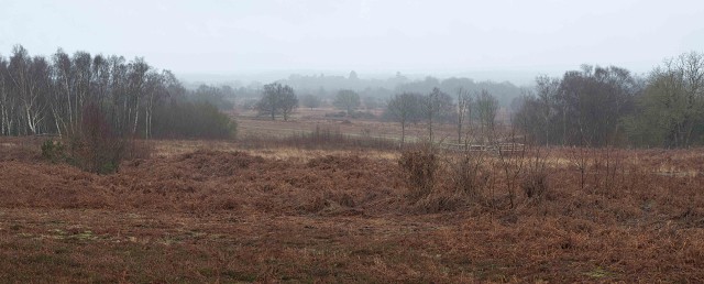
In 2011 we found two early Neolithic flint scrapers on this part of the common. They have recently been dated by the county archaeologist to between 4,000 and 3,000 BC. The first finds of their kind in the area they are a very important dating milestone in the occupation of the area.
This also happens to provide quite a good contextual image since it is just about the highest point in the area and almost the whole of the parish can be seen here - a patchwork of woods, small fields and open heath stretching south towards the Sussex Downs. Prior to the local government re-organisation of 1933 the parish boundary continued much further south to take in part of the southern slopes of the Downs - at that time this was the longest parish in England. The image also shows that, despite being in south east England it is a fairly thinly populated area of isolated farms and three smallish settlements - South Chailey, Chailey and North Chailey - which have developed along the two main roads that cross the area.
Next week: what the Romans did for us.
130
views
- 0
- 0
- Olympus E-410
- 1/100
- f/9.0
- 42mm
- 400
Comments
Sign in or get an account to comment.


