
High Whin Sill Factor - High Force, Teesdale
The North Pennines Area of Outstanding Natural Beauty and Global Geopark is a stunning English landscape of open heather moors, dramatic dales, tumbling upland rivers, wonderful woodlands, distinctive plants, fantastic birds, colourful meadows, stone built villages, and has a heritage of mining and industry. It also has glorious waterfalls.
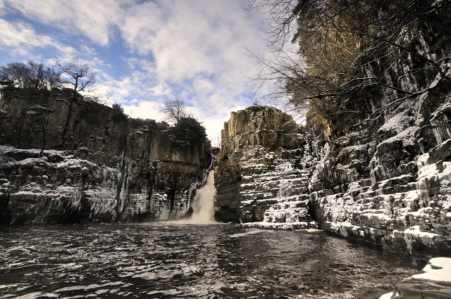
Being in the right place at the right time is not usually one of my strong points, but when we visited High Force today, the snow stopped and blue sky appeared just long enough for me to get a good few shots of this, one of the most impressive waterfalls in England, today made even more spectacular with giant icicles all around the basin. As the sun came out a rapid melt ensued and we had to make a retreat in the end not because the weather turned, but because we heard icicles falling and feared being impaled.
The River Tees has been plunging into this gorge for thousands of years but the rocks it reveals are much more ancient. The falls are 21 metres tall and the water plunges over the Whin Sill, a layer of hard dark volcanic rock known locally as 'Whinstone'. This layer formed about 295 million years ago when England was somewhere near the Equator (unlike today!) and molten rock at over 1000°C forced its way towards the surface but spread sideways underground as well, forcing its way in between layers of sedimentary sandstones, shales and limestone and forming a 'sill'. After millions of years of erosion at the surface, it is now exposed and is particularly well displayed at the top half of the falls where its vertically oriented columns contrast with the horizontal sedimentary rocks underneath. The softer layers of shale and limestone form the lower layers of the falls, which is slowly but surely retreating up the Teesdale valley as these layers erode away and the Whin Sill collapses into the river.
You'll get a better view of the icicles in LARGE.
Comments
Sign in or get an account to comment.


