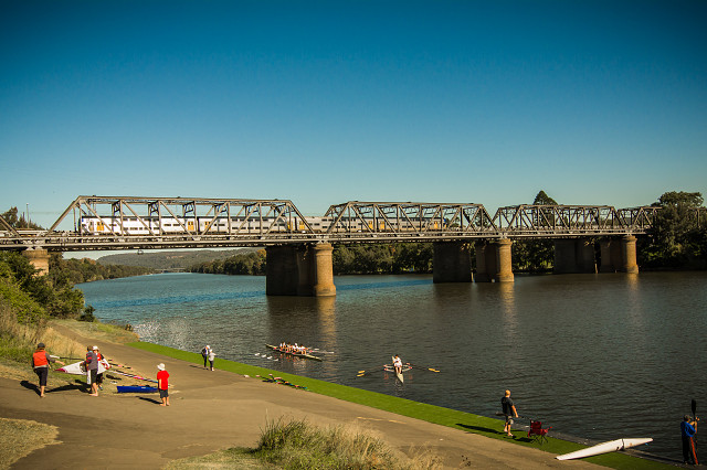
VICTORIA Bridge - Crosses the Nepean River
Thank you for the feedback re my flower shots, but we are of in a different direction today.
This is the Victoria Bridge which was opened in 1867 to carry traffic mainly horse drawn initially and trains (one of our current trains is crossing as I took pic) over the Nepean River. The activity with the rowers is due to the Nepean Rowing Club being based here. With the Olympics in 2000 a major rowing complex was built near by just north of Penrith.The River was very active with many rowing events prior to that. Info from the ole Wiki explains.
View Large
The Victoria Bridge over Nepean River, officially known as The Nepean Bridge, is a wrought iron plate girder bridge that crosses the Nepean River at Penrith in the western suburbs of Sydney, New South Wales Australia. Completed in 1867 under the supervision of John Whitton, the Engineer-in-Chief of New South Wales Government Railways, the bridge initially carried rail and horse-drawn traffic, and was converted in 1907 to exclusively carry the Great Western Highway. The bridge is managed by Roads and Maritime Services and is listed on the NSW State Heritage Register.
The bridge is the oldest surviving crossing of the Hawkesbury-Nepean River. As at 2009, Roads and Maritime Services estimated that Victoria Bridge carried an average daily traffic of 25,000 vehicles per day.
Prior to the construction of the Victoria Bridge, a punt service was located at the site of the bridge. Following the discovery of Gold in the west of the Great Dividing Range demand for a permanent river crossing increased. A timber bridge was constructed with private funds, charging a toll for its use. Opened in January 1856, the bridge was destroyed by floods in 1857, rebuilt and again destroyed in 1860. Designed by Engineer-in-Chief of Railways, John Whitton, construction began in 1864 and was completed in 1867. Originally it took one railway line and a road across the river, however in 1907 another bridge was constructed a few metres to the north which thenceforth took two railway lines across the river, and the original bridge reverted to road and pedestrian use only.
The bridge is significant in the development of the colony of NSW as it allowed the railway, which previously terminated at Penrith, to reach the Blue Mountains and beyond, as well as providing continuous road passage across the river using the Great Western Highway.
The 1867 bridge is similar in design to the older Menangle Railway Bridge over the Nepean River at Menangle, southwest of Sydney. The Menangle bridge has always been used only for rail traffic, and as of 2007 is still in use by the railway.
Today the bridge's significance as a road route to and from the Blue Mountains is diminished. The M4 Western Motorway has replaced the Great Western Highway as the main arterial route, crossing the Nepean River at Regentville. The M4 and the Great Western Highway join/separate at Lapstone Hill.
The bridge maintains its significance as a local tourist attraction and a centrepiece to sporting events along the Nepean River, as well as continuing to serve as vital link between the suburbs west of the Nepean, such as Emu Plains, and the major suburban centre of Penrith. The 1907 railway bridge still takes the Main Western and Blue Mountains railway lines over the river.
An undivided pedestrian pathway approximately 1.3 metres (4 ft 3 in) is located adjacent to the roadway. Following community advocacy, in 2010, Roads and Maritime Services commenced a feasibility study into a shared pedestrian/cyclist pathway over the bridge
You can see the M4 freeway bridge to the distance and can be seen in my Portfolio M4 Freeway Bridge
There are some other shots as well in the portfolio /Landscape
Enjoy
Comments
Sign in or get an account to comment.


