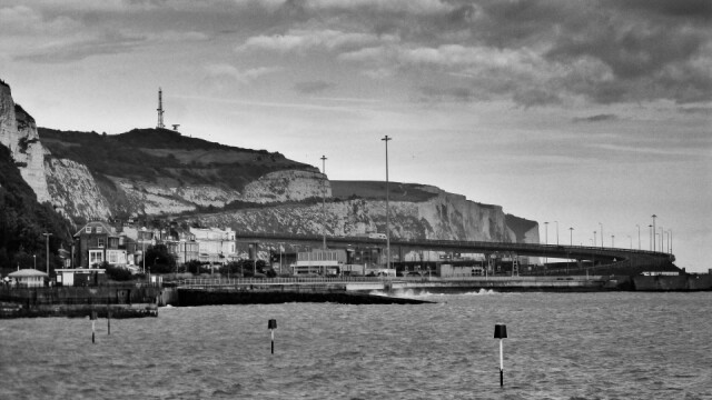
The A2 into Dover
J had a lunchtime appointment at the community hospital in Dover, after which we took the opportunity to go for a further look at the seafront and marina area where we tried to sketch three weeks ago. It was very windy and overcast but not cold, and although it's not the prettiest of places, there's a huge amount of visual interest: frequent arrivals and departures of ferries in the Eastern Docks, waves crashing against the piers, and a few hardy swimmers just off the beach. Walking west to the marina, we crossed the bascule bridge which allows taller boats to enter the inner harbour, saw the old clock tower and lifeboat station, then skirted the marina with its crowds of yachts and rows of motor launches. Beyond the forest of masts were the walls of the eastern docks, and behind them the iconic white cliffs topped by the impressive fortifications of Dover Castle. There is also a clear view of the final, elevated section of the A2, shown here, which loops down from clifftop to sea level to carry substantial amounts of traffic to the ferry port and the town. The A2 runs from London to Dover, roughly along the route of the Roman Watling Street and an older Celtic way, though many re-routings and bypasses have shifted its course over the centuries. This elevated section was built in 1976. Anyone familiar with the area will realise that London road, running from the seafront to Temple Ewell and on to Lydden before meeting the current A2, was once the route of the A2 into Dover. I find this huge curve of road interesting, and like the way the eye then continues its line along the seafront railings; I also like the shapes of the cliffs and the terraces and crescent of houses tucked between their base and the shoreline. My walks these days are almost exclusively rural, so I really enjoy the occasional opportunity to view and photograph buildings and structures.
Comments
Sign in or get an account to comment.


