
Rainy day local history
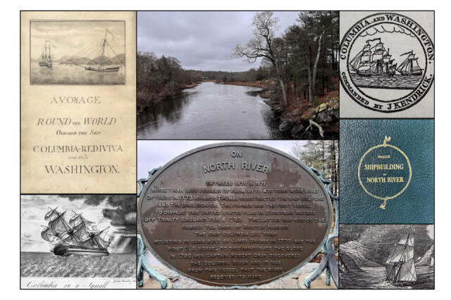
As I was coming back from some local errands this morning I stopped on the old bridge over the North River to make a couple photographs. The river is rich in history as related on the large plaque in the collage and below.
For over 150 years, some of the largest shipyards in America were located along the banks of the North River, in what are now the towns of Norwell, Pembroke and Hanover. The locations of the shipyards were far upstream, several miles from the river’s mouth. The location of the Brick Kilns Shipyard, noted on this 1794 map was located near what today is its namesake street off route 139 in Pembroke. Other shipyards were located across the river near the present day location of the Brigantine Circle development in the town of Norwell. Further downstream was the Brooks-Tilden Shipyard in North Marshfield, which is a now conservation land owned by the town.
Perhaps the most famous ship to be built in the North River shipyards was the Brig “Beaver” which was owned by the British East India Company. Docked in Boston Harbor with a full load of Tea on the night of December 16th, 1773, American Revolutionaries snack aboard and threw the tea into the harbor in an event which would henceforth become known as the Boston Tea Party.
Equally interesting but likely less well known is another North River-built ship, the Columbia. The first American ship to circumnavigate the globe, she was was used in the booming trade with China. Columbia was under the command of Captain Robert Gray on trips to Canton, China. Finding himself outbid by European merchants trading gold and silver, Gray had the idea that he would obtain furs to trade from the American Pacific Northwest en route to China. Hearing rumors of a great river in the Northern Pacific, he set out to find it. According to records* it was May 12th, 1792 when Captain Gray first spotted a great open bay and a wide river along the Pacific coast. He named the river the Columbia after his ship. This name still holds today, as does the name Gray’s Bay. Visible on any modern map, these vast bodies of water separate the states of Oregon and Washington. Today, the city of Portland, Oregon is located at the intersection of the Willamette and Columbia Rivers.
~Bostonharborbeacon.com
I have canoed this river from the Indian Head (which is just around the corner from us) to the North River and the tidal marshes as it meets the Massachusetts Bay and the Atlantic. That canoe voyage was in late April 1979 with my brother and Suzanne, my late Swedish friend. T and I kayak now on the twelve mile scenic, tidal river.
For the Record,
This day came in dark and stormy with spring temperatures. Tonight we may have a huge temperature drop, below freezing making the roads icy, early tomorrow.
All hands happy to be in, out of the storm.
Comments
Sign in or get an account to comment.


