
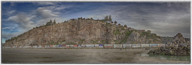
Clifton Cliffs
This view of the Clifton Cliffs near Sumner, shows Shag Rock on the right. The red lines and strata in the cliff shows its volcanic origin.
This cliff has been subject to several serious rock falls due to the earthquakes, since February 2011. All the houses along the top edge have been deemed unsafe and will be demolished. The land has been zoned 'red' and won't be safe to be built on again. You'll be able to see a lot of rockfall at the bottom of the cliff, in the middle. Two of the houses at the top, in the middle, are very close to ending up at the bottom.
My house is further back on the hill (phew) and has been zoned 'green', but has yet to have its final inspection, to ensure that any retaining walls are sound - they look fine to me. And then the repairs will begin . . . . . I'm not holding my breath.
The containers along the bottom of the cliffs are there to ensure the safety of all passers-by, in the event of another quake.
I've walked and jogged (not so much lately) here nearly every day in the past 12 years - you could say it's my stomping ground :) I love it!
Comments
Sign in or get an account to comment.


