Four Shires Stone
It was the monument for William Smith that we included in our cross-country journey but, having seen it and continued, I suddenly remembered this stone from years ago, before I joined Blipfoto and did a quick Google search.
Finding that, by back-tracking a little, we could see that too, Mr Flum agreed. This was a generous gesture as we had failed to find anywhere to park in Chipping Norton and were both in need of lunch.
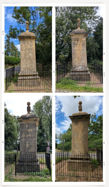
This 15 feet high stone was erected in the mid-C18 on a site previously marked by four separate stones, as noted on John Speed's map and several other references over subsequent years .
Made of Cotswold stone, the four faces are inscribed with each of the four counties represented - Gloucestershire , Warwickshire, Oxfordshire and Worcestershire. Below the ball finial is a sundial on each face, however, these are indistinct.
By 1931 County boundary changes removed Worcestershire from the foursome, in 1955 a lorry collided with it, demolishing the pillar. By 2019, the stone in poor condition, a committee was set up to raise funds for a restoration, this completed in 2022. The stone is currently Grade II listed.
Photos successfully acquired (despite the brambles and nettles on the Oxfordshire side), we continued our journey on the Fosse Way and are now in Rutland.
Oh, and may I recommend the Cotswold Cafe on the A44, who make amazingly delicious bacon and mushroom quiche. Any bikers out there, you'll be most welcome.
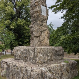
Extra photo of William Smith monument in Churchill. He is regarded as the 'Father of Geology ' having created the first geological map of Britain yet did not receive due reward.
.
Comments
Sign in or get an account to comment.


