
The end of the pier at Arlingham
An offering for the 'Derelict Thursday' challenge as arranged by Sarum Stroller
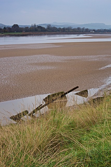
These derelict remains stuck in the mud are on the Arlingham bank of the River Severn, where the open farmland on a big meander looks across to the high ground of Newnham on the western side. I think this is all that is left of a pier where the ferry would have moored up in years gone by. This is a very ancient site and this place formed one of the lowest points where a crossing of the Severn was possible. A droving road approached here from central Wales and once the animals had been ferried over the water they would have continued into England at this point and probably been driven all the way to London to provide a supply of fresh meat.
I came here today to see the river and eat my falafel sandwich for lunch before I went on to photograph an old derelict barn I’d spotted near a local village a few days ago. On the far bank I also spotted some wrecked barges that are being used as a wharf at a small boat building yard, but I didn’t think they would be easy to see at that distance. There was also an old rescue boat chained to a post at the top of the river bank’s edge next to a life buoy. The boat looks in dangerous condition, and being chained up wouldn’t be very useful in an emergency.
There is an old pub here, called ‘The Old Passage’, which used to serve the ferry business many decades ago. Now it has become a rather fine seafood restaurant, which is so pricey that we can’t eat there, although many years ago I was taken there by Tanya and her husband Nicky.
You can see where exactly this is by looking at the location map I have marked.
From the website ‘British history online’
Newnham stands on the right bank of the Severn 10 miles south-west of Gloucester at a point where the river was crossed by a ford and a ferry. Flanked by the river on one side and the Forest of Dean on the other, Newnham was a port trading in timber, in oak bark for the tanning industry, and in coal; it was also once a minor centre of tanning, glass making, and shipbuilding.
Newnham is thought to have been settled because of the relative ease of crossing the river there. The commanding site, close to the water's edge but above the flood level, was clearly a contributory cause. The crossing at Newnham was presumably in use in the first century A.D., and if the ancient line of the road through Arlingham reached the river opposite Hawkins Pill, at the north-east corner of Newnham parish, it was to exploit the ford that could be used there at low water. A stone bench across most of the river bed was connected to the shore by a bed of sand affording a firm crossing. In 1802, however, the river's channel changed direction and washed away the bed of sand.
The first known reference to the ferry is of 1238, when the king granted the woman keeping the passage of Newnham an oak for building a boat. In the later 13th century or early 14th Gloucester Abbey granted to Richard Head of Ruddle a moiety of its passage of Newnham, and the ferry continued to belong to the lords of Ruddle manor after the Dissolution of the monasteries until the early 19th century. In the later 18th century the ferry, which carried horses and carriages, was described as very safe, but at a later period the absence of a long jetty on the Arlingham side meant that the passengers often had to be carried across the mud on men's backs.
By 1810 the rights in the ferry had been acquired by the Severn Tunnel Company, which proposed a tunnel under the river between Newnham and Arlingham, secured an Act for the purpose, and began tunnelling. The abortive tunnel scheme was followed by many different schemes for a bridge in between 1842 and 1950. The ferry survived until after the Second World War, when it went gradually out of use.
Comments
Sign in or get an account to comment.


