
Moorabool Falls
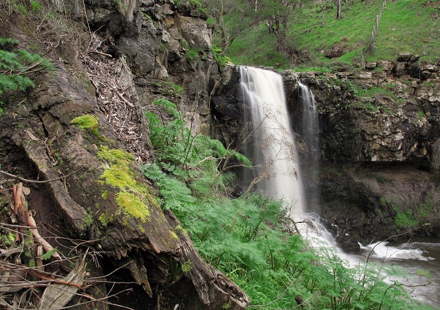
Earlier in my country sojourn, I was thrilled to undertake the short but puffing 3 kilometre/2 mile walk to the much underrated and not well known Moorabool Falls located 18 kilometres/ 11 miles south of the large central Victoria city of Ballarat. Not as famous as its more spectacular sibling, Lal Lal Falls (refer to blip of 31st August 2010), these 27 metre/88 feet basalt structured single drop Falls formed as a result volcanic activity over 2 million years ago and have been slowly retreating back up the Moorabool River at the rate of 13 millimetres/0.511811 of an inch per year - apparently quite fast in geological terms.
Part of country of the Toola-Buluk clan of the Warthwurrung Nation, the indigenous custodians of the Falls, the name 'Moorabool' has been translated to mean either 'mussels' or less reliably, 'stone-curlew'. Either connection is not obvious these days. The Falls were first surveyed by Europeans in 1839, reputedly guided to the location by the famous escaped convict William Buckley (1780-1856). Buckley, a cashiered (and apparently quite brave) soldier (with minor connections to aristocracy) turned petty thief, was sentenced to 14 years Transportation from England to the then colony of New South Wales - akin in the early 1800s to being sent from the Earth to the Moon in a sense. In 1803 he scarpered the fledging and ultimately unsuccessful settlement based at present day Sorrento (112 kilometres/70 miles southwards of Melbourne) on the Mornington Peninsular. Buckley fled with three others of all whom, except Buckley, soon returned to be savagely punished for their termity. Buckley, after much tribulation and near starvation, was adopted by a local indigenous clan (believing him, due to his pallid skin, to be the reincarnation of a lost ancestor). Buckley lived with the clan for over 30 years, mostly on the western side of Port Phillip Bay near present day Queenscliff (104 kilometres/65 miles south of Melbourne), learning their language and adapting to their customs. I might add the distance by foot from Sorrento to Queenscliff around Port Phillip Bay is over 272 kilometres/169 miles and there were no maps, bridges, roads etc in 1802 to help Buckley on his tramp. About two years ago, over a period of 12 unconnected days, I roughly followed Buckley's route, mind you this was along now manicured beaches (for the most part), over impressive bridges and always near facilities in complete opposition to Buckley's depredations. My greatest 'obstacle' was getting the Tides correct! With the arrival in 1835 of a settlement party from Tasmania (then called Van Dieman's land, so named after an obscure Dutch Civil Official by the erstwhile Explorer and the very gifted Dutchman sailor, Abel Tasman (1603-1659). This unprincipled party was led by one of the so called 'founders of Melbourne', the notorious land crook John Batman (1801-1839). It was Batman, intent of pure greed and profit, who cheated the local indigenous custodians by means of an absurd treaty to 'purchase' a massive amount of land in exchange for a few trinkets. This I am sure will be the subject of another essay for another time I reckon. Though, it could be argued that Melbourne was 'initially founded' on the basis of a very dodgy land deal. Nonetheless, Buckley made his presence known to the astonished colonisers and sought 'return' to civilisation. Later, Buckley acted as interpreter and intermediatory between the European invaders and those they were to ultimately usurp. Buckley eventually returned to Tasmania, a tad disillusioned (though granted a full pardon, probably due to the astonishment of his survival by the corpulent apparatchiks in England being successors to those class riddled ones who sent Buckley on his way those decades previously). Buckley married, happily, becoming a successful merchant and lived a quiet dotage. His story is one worth exploring.
The track from Lal Lal Falls mostly follows the escarpment between Lal Lal Creek (which feeds Lal Lal Falls) and the Moorabool River (Lal Lal Creek is a tributary of the River) before dipping down to meet the Falls. The walking course is located within the present day Lal Lal catchment area of which nearby Bungal Dam is the beneficiary, now filling up with water for the first time since the 1990s. It was not until 2008 that this track opened following the original 1885 route laid down by a bunch of indefatigable amateurs belonging to the pompously named Ballarat & Melbourne Filed Naturalists Club - I have seen photographs of them on 'excursions' and some of the clothing is 'cumbersome' to say the least! Gortex and designer boots they ain't wearing in them days ... It is a superb walk I hasten to add, as you get two dramatic Falls with the only cost some stretch of your leg muscles.
ps
the photo is an amalgam of three bracketed exposures merged through the PICASA photo software
312
views
- 0
- 0
Comments
Sign in or get an account to comment.


