
The Great Ocean Road
It is not my habit, in the least, to write of roadways. My inclination is the Australian landscape eschewed of bitumen ribands and monstrous carbon spewing vehicles. However, there is a remarkable engineering and construction feat located along the south-west coast of Victoria that extends for 270 kilometres/168 miles that mostly hugs the shoreline beneath steep cliff and hill faces passing through a lush temperate rainforest that features breathtaking landscapes.
This road is dubbed 'The Great Ocean Road'. Conceived as far back as the 1860s. Formal construction commenced in 1919 and completed through stages in 1932 by over 3,000 returned veterans from Australia's Volunteer Armed Services who fought in World War I (1914-1918). It was built as a memorial to the over 60,000 that perished in that dreadful outbreak of violence and is considered one of the longest, if not one of the most impressive memorials to sacrifice in the world. The idea of this winding road was to not only provide employment but to link a number of coastal towns that previously been twined by unreliable overland tracks and dirt roads that snaked through the Otway Ranges inland from the coast. Such towns as Torquay (at the road's formal start), Anglesea, Aireys Inlet, Lorne, Wye River, Kennett River, Apollo Bay, Lavers Hill, Peterborough, Port Campbell (and the famous twelve apostles coastal feature), Warrnambool onto Port Fairy (the road's formal end).
For tens of thousands of years the area the road traverses and its surroundings were the home of the Gunditjmara People and Wathaurong people of South West Victoria. These indigenous peoples were noted fishers and had tuned into the rhythm of the earthscape establishing basic farming and aquaculture. European settlement started to occur in the 1840s with the tenuous establishment of small coastal villages mainly linked by the sea. Early tracks and roughshod dirt roads did not meander through the lush forests beyond the windswept coast until the 1850s. These were roads used by hardy Bullock drivers and their beasts as well as early loggers. It must have been, I would suggest, a very tough existence and how those pioneers plundered their way through the rainforest finding locations we now take for great beauty, quite remarkable.
Nowadays the road not only provides that important link but is a significant tourist attraction in its own right. In some respects, for residents of Victoria and visitors alike, it is a rite of passage to have driven the length of this road. I first did so in 1975 on a very tinny sounding Honda 125XL Motor Bike in a rather carefree manner. It is also important as an access point to enable experiences of the large Great Otway National Park and the extraordinary landscapes located within this temperate rainforest sanctuary.
During the long construction period, it was calculated due to the rugged and difficult terrain, plus seasonal misadventures, approximately 1.5 kilometres/just under 1 mile was lain down per month. Conditions for the workforce were difficult with canvas tents for accommodation, communal kitchens and very basic personal facilities used for most of the period of construction. Workers were often away from their families and home for months, if not weeks at a stretch. On average, each labourer received about 10 shillings per day (roughly $1). There was no sick leave provision, little if any workers compensation for injury or disease and not much by way of entertainment. Every commodity had to be carefully brought in, including construction materials. Most of the hewing of the landscape was done by pick and shovel, supplemented by sparing uses of dynamite/TNT. The latter was due to the dangerous nature of the landscape with its numerous rock falls and land slips that caused the death and injury to many, often unexpectedly.
There is an anecdote, often repeated when talking to locals, that in 1924 a steamboat, the SS Casino, became stranded along the coast after hitting a submerged reef. As a result, in order to save the vessel, the Skipper ordered the jettisoning of over 600 barrels and cases of beer and spirits, which in turn washed up onto the shoreline near where the road workers were deployed. Gleefully looting the cargo, the workers ended up going on what was reputed to be a two week long drinking binge or as it was more politely referred, a two week drinking break.
The road opened in two sections. The first being Lorne through to Apollo Bay in 1922. The final section from Apollo Bay to then Warrnambool was completed by 1932. Additional sections at either end have been formally added making up the 270 kilometre/168 mile length. Initially the road was narrower than what it is today with barely room for two vehicles to pass and most of the road was compacted dirt. Though today it is well signposted, fully sealed, albeit with two narrow lanes, some parking bays and passing loops. Numerous landslips, rockfalls, water and storm damage have occurred of the years and continue to do so causing (at times) lengthy closures. Bush fires that have swept down from the Otway Ranges have also closed the road and ravaged coastal towns. The last killing fires occurred on Ash Wednesday, 16th February 1983, which practically destroyed the towns of Lorne and Aireys Inlet. Tragically, three people died in the district (Otway Ranges) with over 800 homes lost. Overall, the fires killed 75 across parts of Victoria and South Australia and razed 210,000 hectares/518,921 acres in the Otway Ranges region alone. Nowadays, little evidence of these devastating fires remains and the towns along the route of The Great Ocean Road are thriving as tourist destinations, especially in the summer months.
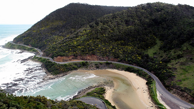
In the photo, you see a small section of the road taken from a famous vantage point called Teddys Lookout near Lorne. The view is to the south-west and you can see the type of terrain the road clings with Bass Strait (next stop Tasmania) on the left and the Otway Ranges hinterland on the right. Saint Georges River empties into the sea just below and it is this river that feeds Phantom Falls, which I hope to share a photo in the next day or two when I plod my way along the banks of this river. It is a fine location and I should think if I were a resident or Lorne it would be a place to become an outdoor office where I could indulge in cloudspotting and watching the seasons change. Next to the Lookout is Queens Park which offers good picnic spots and a number of steep walking tracks that flank up and down the near sheer cliff faces. During my visit, after a brisk uphill walk from Lorne of about a couple of kilometres, I was treated to masses of flowering clematis especially, along with wattles which are still in their magnificent bloom. Even some early starting native orchids - always a thrilling sight to me - have begun to reacquaint with the Sun from their winter quarters beneath the soil. I also noticed a number of small wallaby troops shyly scurrying about in the bush and of course there was an orchestra of birds namely honeyeaters, wrens and magpies. It would be an ideal location, I should think, for landscape painters, with its expansive views. Well worth a visit.
245
views
- 0
- 0
- Canon PowerShot G10
- 1/100
- f/4.0
- 6mm
- 80
Comments
Sign in or get an account to comment.


