
Occasional Stones series - Stancombe Cross
'The Cross-Shaft
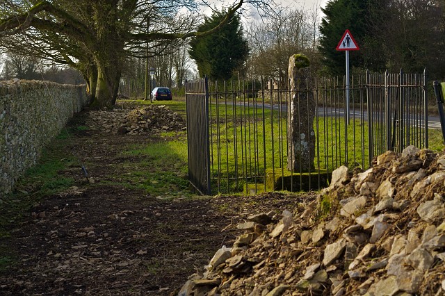
The square shaft and a base member of a now headless Saxon Cross, of the tall northern type (Bewcastle Cross), dating c. AD700 once carved with tiers of holy figures within square and round headed niches. Probably brought from Stancombe Cross-roads c.1820, for use as a Bisley parish boundary stone. Recognised 1928, and since restored and protected by the Gloucestershire County Council.
ST. C. B.'
(as written on the plaque mounted on a pole just outside the railings protecting this ancient monument.)
The Cross was carved with Christian motifs of the Anglo-Saxon period and perhaps dates to the middle of the 8th century. Virtually all of the carvings are now sadly illegible. In 1929, it was reunited with a square plinth stone and re-erected within these railings.
The road follows the path of a classic ancient trackway, which gently wanders along the ridges of this part of the Cotswold hills, and before it reaches here it is called Calf Way. The Stancombe cross-roads, which was mentioned on the plaque, refers to where the old Roman route from Gloucester, via Painswick to Cirencester crosses this road, on the highest point around. This view is 330 yards from there, looking south-west towards Lypiatt Park, whose large house and a relatively small bit of land is the last remnant of a vast estate that has been pivotal to the local economy for hundreds of years. The wide grass verges show the extent of the original track, which almost certainly looks like a drovers route, and before tarmac, the road would have meandered between the walls and the hedges which probably preceded them, formed by the wandering animals.
I have been watching the progress of the stone-wallers who have been hard at work here for many months, with many more to go, as they completely rebuild the wall. I came up here to the relatively flatlands above the valleys, to go to the Stancombe Beech farm shop which I often mention because it is so fab, so I see their progress each time I pass by. Countless people must see them too, as it is a very busy road, and probably has been for thousands of years. It is now rare to see such investment by a farmer in repairing the boundary walls. The pile of rubbley stone is what is left of the old wall and the debris which surrounded it. Behind the wall a field slopes down to the stream that springs from the ground just outside the ancient settlement of Bisley, and flows all the way to the Golden Valley where it joins the River Frome.
There is documentary evidence that Stancomb(e) was the meeting place of the Bisley Hundred, where the local Witanagemot or Anglo-Saxon village council met. And the 1928 Ordnance Survey map of this area records Witantree Farm just north of Stancombe. Bisley is an old settlement pre-dating Stroud by many hundreds of years. Stroud only grew up as a small outlying settlement of Bisley in about 1270, when the church was built.
I talked to one of the young stone-wallers, who have just finished this section, and he was happy to let me come back and photograph them in action. I will do so soon, but only when the weather is better as it was extremely windy and cold today.
ps
The road sign indicating 'be aware of children' is outside the only house on this long stretch of road and near the bus stop. I have never seen any children.
Comments
Sign in or get an account to comment.


