
El Morro National Monument
We got an early start this morning and headed west out of Albuquerque for about 70 miles to El Malpais and El Morro National Monuments. We had been told of El Malpais yesterday at the Visitor Center so we headed there first. El Malpais (pronounced el-mal-pie-EES) means "the badlands", so named due to the volcanic features such as lava flows, cinder cones, pressure ridges and complex lava tube cave systems that dominate the landscape.The lava is bordered in the east by a long sandstone escarpment, with cliffs up to 400 feet high, providing viewpoints over the lava fields. The most recent lava flow emanated from McCarty's Crater within the last 2,000 to 3,000 years, relatively recent in geologic terms.
First we visited the Bandera crater region in the northwest part of the park, and is actually still privately owned. There are two trails - one to the Bandera crater itself and the other shorter one to an ice cave. The Bandera Crater is the largest volcano in the region. It erupted around 10,000 years ago. The crater that remains is nearly 1200 feet wide at the top and roughly 750 feet deep. Over time, erosion and gravity take their toll on the crater and slowly fill it with cinders and rocks. You can see a picture of the crater here.
The ice cave was most interesting. The Ice Cave is the partially collapsed remains of a lava tube, where, due to a combination of factors, even during the heat of a New Mexico summer, the temperature never rises above 31 degrees F. As rain water and snowmelt seep into this cave, the ice floor thickens. The floor of the ice is now approximately 20 feet thick. Early settlers used to mine the ice, but all removal was stopped in 1946.
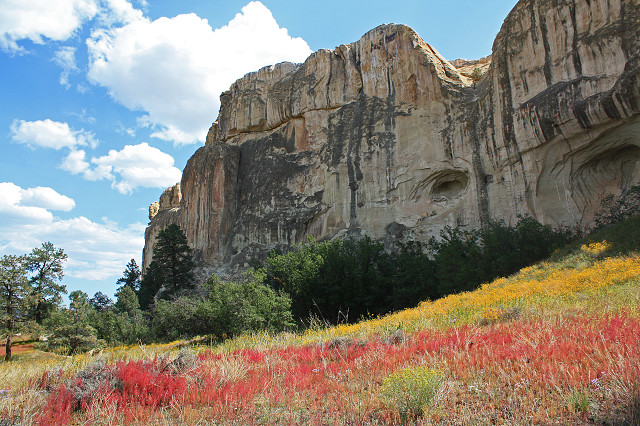
Then we continued further along the road to El Morro National Monument, where today's blip was taken. El Morro is a fascinating mixture of both human and natural history. A reliable waterhole hidden at the base of a sandstone bluff made El Morro (the headland) a popular campsite. Ancestral Puebloans and Spanish and American travelers carved over 2,000 signatures, dates, messages, and petroglyphs for hundreds of years.A 2-mile loop trail takes you past hundreds of inscriptions, and then continues to the top of the sandstone bluff, rewarding you with spectacular views of the Zuni Mountains, the volcanic craters of the El Malpais area in the distance, and the El Morro valley. Also up on the plateau are the Ancestral Pueblo ruins of Atsinna, or "place of writings on rock". Between approximately 1275 to 1350 AD, up to 1500 people lived in this 875 room pueblo. The location was strategic-it was near the only water source for many miles and located atop a nearly impenetrable bluff.
Then we returned to El Malpais and visited Ventana arch, the largest of New Mexico's accessible natural arches, Sandstone Bluffs Overlook, which offers a dramatic viewpoint over the park's lava flows and the impressive sandstone cliffs that border them, and finally walked a little of the Narrows rim trail.
A wonderful day. If you're interested in seeing more photos from the day you can do so here
One year ago: Myers barn
Comments
Sign in or get an account to comment.


