
The Beauty Shot with the 300mm
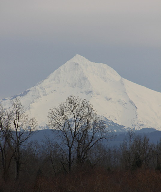
If you follow anybody from the Portland/Vancouver area, you have sometime or another seen a blip of Mt. Hood, the 4th tallest in the Cascade Mountain Range. I believe I have blipped Mt. Hood before, but here it is again. It is approximately 11,240 feet high. No I have not climbed it, but my step-dad has. I just recently learned that (or re-learned that, as I probably knew at one time and forgot) and I was impressed. Mt. Hood is a volcano who's last volcanic "burp" was in 1907. The last large volcanic activity on the mountain was 170-210 years ago. Once in a while an earthquake "swarm" will occur, and someday this volcano might wake up, but it is considered dormant. If it does that, it will wreck a lot of skier/snowboarder enthusiasts plans for the weekend. The United States Olympic Ski team trains on Mt. Hood.
I went to aunties for errand/lunch day and it was a day with high overcast skies, a weak sun shining through but no rain. On the way back home I hung a left, went down 1/2 block and went into this parking lot of a large industrial building that is situated on a bluff overlooking a large marshy area. As I went into the little parking area, lo and behold there was the perfect shot of Mt. Hood. And thank you very much, Mother Nature.
This is more the view that I saw. The low land marshy area and beautiful Mt. Hood in the distance.
The Multnomah (the American Indian tribe) name for Mount Hood is Wy'east. In one version of the legend the two sons of the Great Spirit Sahale fell in love with the beautiful maiden Loowit who could not decide which to choose. The two braves, Wy'east and Klickitat, burned forests and villages in their battle over her. Sahale became enraged and smote the three lovers. Seeing what he had done he erected three mountain peaks to mark where each fell. He made beautiful Mount St. Helens for Loowit, proud and erect Mount Hood for Wy'east, and the somber Mount Adams for the mourning Klickitat.
There are other versions of the legend. In another telling Wy'east (Hood) battles Pahto (Adams) for the fair La-wa-la-clough (St. Helens). Or again Wy'east, the chief of the Multnomah tribe, competed with the chief of the Klickitat tribe. Their great anger led to their transformation into volcanoes. Their battle is said to have destroyed the Bridge of the Gods and thus created the great Cascades Rapids of the Columbia River.
The mountain was given its present name on October 29, 1792 by Lt. William Broughton, a member of Captain George Vancouver's discovery expedition. Lt. Broughton observed its peak while at Belle Vue Point of what is now called Sauvie Island during his travels up the Columbia River, writing "A very high, snowy mountain now appeared rising beautifully conspicuous in the midst of an extensive tract of low or moderately elevated land (location of today's Vancouver, Washington) lying S 67 E., and seemed to announce a termination to the river." Lt. Broughton named the mountain after a British admiral, Samuel Hood.
Lewis and Clark were the first Americans of European descent to see the mountain, on October 18, 1805. A few days later at what would become The Dalles, Clark wrote "The pinnacle of the round topped mountain, which we saw a short distance below the banks of the river, is South 43-degrees West of us and about 37 miles (60 km). It is at this time topped with snow. We called this the Falls Mountain, or Timm Mountain." Timm was the native name for Celilo Falls. Clark later noted that it was also Vancouver's Mount Hood.
343
views
- 5
- 1
- Canon EOS REBEL T2i
- f/8.0
- 300mm
- 320
Comments
Sign in or get an account to comment.


