Playing a name game
I couldn't get to sleep early this morning, after yesterday's late night travels. At one point I picked up this book, which I'd recently borrowed from the local library, for the second time. I'd had to return it after continual renewals, having prior to that been the first person in years to borrow it. Then I was told someone wanted it. A few weeks later and I've found it back on the shelf again, much to my delight. Yes, delight!
It is The place-names of Gloucestershire, Part One by A. H,. Smith of the English Place-name Society Vol: XXXVIII. Published by Cambridge University Press 1964. I think this book was bought then.
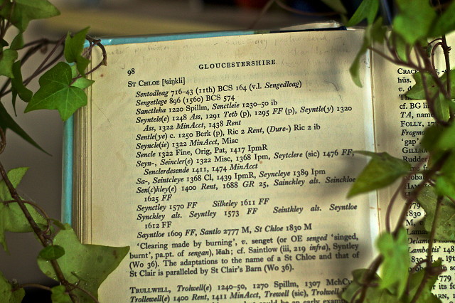
The book opened at this page, so I wondered whether the last user had been reading it avidly too. I thought it was interesting as an example of how a place-name changes and adapts over time. There is so much we can learn from names, ideally when allied to an old map, to tell us about how where we live may have evolved.
St Chloe is a small hillside area running off the edge of Minchinhampton Common, down into the adjacent Nailsworth valley, and is now a few residential houses, and rather plush at that. I had always wondered why such an apparently French sounding name was sited here, notwithstanding that manor of Minchinhampton was given to the Abbess and Nuns of Caen, in Normandy, France, in 1086 by her relation William the Conqueror, as he came to be known here.
The book lists in time order any authenticated reference, mostly from charters, books and maps, to a place-name and you can see this list here. After each iteration of a name, a date is given for its source, followed by the reference which is somewhat coded.
I thought it would be interesting to show how a place referred to in 716-743 as Sentodleag (and also Sengedleag) in a local charter which would have been used to demarcate the landscape at that time.
This comprised two parts: 'Clearing made by burning', v. senget (or Old English) senged 'singed, burnt', and Leah meaning a clearing, probably in a wood.
By 1322, it had become Seyncle), and by 1570 it was Seynctley. The current name arrived, or was first recorded in 1830 on the Tithe Awards map, as St Chloe.
Yesterday as I left for Birmingham, I bumped into Neil, who is a trained archaeologist, and lives in our street. We have arranged to meet in two weeks and walk again in The Horns Valley which our house backs onto, and he will show me his latest discoveries. I am really pleased, as a few days ago I went to a talk arranged as part of the Nailsworth Festival, about the what happened to the local area when the Romans departed. Prof. Mark Horton, who nowadays is a regular tv pundit, was entertaining and encouraging of exactly the sort of work that Neil is doing. so it will be enlightening to get involved even if peripherally.
I hope you can read at leas so of this page. The sun was setting when i took the picture in the cabin, during a powercut.
Comments
Sign in or get an account to comment.


