
Taken aback when taken back
I've been busy again finalising preparations for an important meeting this afternoon. At lunchtime, I drove up the three miles to the Bisley farm shop to buy a few essentials, including a huge bag of sunflower seeds for the birds to eat. Sally was working in the shop when I arrived and she told me she had something to show me. She took me out the back where there was a plastic bag containing a book relating to my interest in local landscape history and I knew immediately what it was. Her brother Ashley, who is the farmer at Stancombe Beech farm had already shown me the book a couple of years ago and recently I had asked him if I could borrow it for a few days.
He grew up with his parents and brethren at the Lodge of Lypiatt Park Estate, a famous local mansion and its grounds. It was bought in the 1950s by the famed sculptor Lynn Chadwick and his family still live there. Ashley found the book some years ago and it is the official Sale Prospectus of Lypiatt Park Estate from 1919, when the family of Sir John Dorrington were apparently forced to sell it all.
It is a magnificent record of all the Lots, with descriptions of houses, cottages, farms, out-houses, barns, lakes, farm equipment, woodlands and the varied field types amounting to more than 3300 acres, and including twenty three farms.
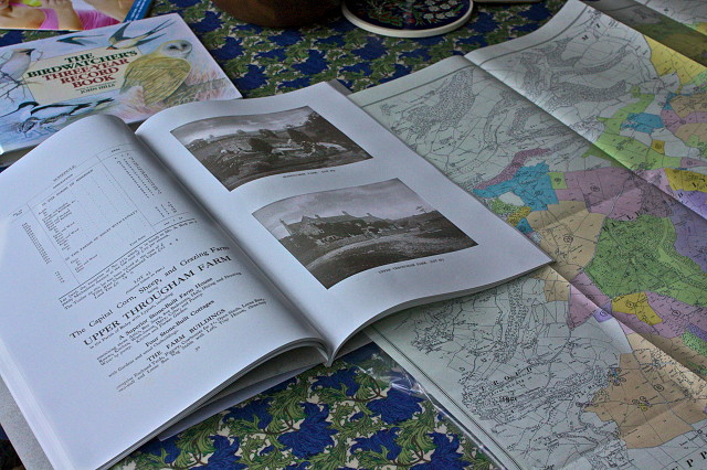
When I got home, and before scooting off to my meeting at Lansdown Hall, I made a sandwich and opened the book. Wonderful! I quickly scanned the details of the Lots but was particularly taken by the attached ordnance survey map which showed every single bit of land and all the buildings.
I grabbed my camera and took this picture of Upper Througham Farm, dating from the 16th century, two miles from Bisley. It is the farm where I came to stay and work for four months in the long hot summer of 1975, the picture of which summons up so many memories and my introduction to the wonderful Cotswolds, to which I have returned off and on ever since, finally moving here in 2003.
I can't wait to study the maps and see the exact lie of the land just after the First World War, when probably not much had changed in the way of life since the 19th century. The coloured areas mark the extent of the properties for sale, whilst in the bottom left hand corner, is where Stroud is located, which in comparison shows you how big the estate was. The area just below the colours was the adjacent Nether Lypiatt estate, which was owned by the Freames and the Clutterbucks when it was split up in the 19th century, and they owned the land on which our house was eventually built just before the Second World War. A series of bygone eras.
The meeting went very well too, and the problems are now over. Results all round.
Comments
Sign in or get an account to comment.


