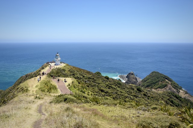
Cape Reinga
Our aim for today was to reach the most northern point of mainland New Zealand. We headed out from the karikari peninsular and headed north on Route 1 towards Cape Reinga, the mostly northerly point on mainland New Zealand. It was a long but gorgeous drive, passing thick forests, low swampy shrub land, huge sand dunes and bright red arid soil banks. As we headed north the vegetation got more and more stunted and less diverse, due to the sandy soil and strong winds. In maori mythology Cape Reinga or 'Te Rerenga Wailua' is the site at which spirits of the dead depart this world and pass into the underworld below. The cape also marks the meeting of two seas: the Tasman sea to the west and the Pacific Ocean to the east. The point at which the sea's meet can be seen by the turbulent water and the changing of current directions.
After walking around the headlands of Cape Reinga Stuart and I headed to Tapotupotu Beach, one of the most stunning and secluded beaches I have ever visited. Within the area was a crystal clear steam that ran into the ocean through a large sandy bay. We rested out feet after the long drive and watched the waves roll in. It was a beautiful spot and we were sad to leave but we still had a 3/4 hour drive to the bay of islands where we had our nights accommodation. On the way to the bay of islands we stopped at a Gumdiggers park, just north of Kaitaia. The park was a interactive outside attraction where you could walk around and learn all about the gum trade of the late 1800's and early 1900's. Numerous large holes are present in the area where workers dug down into the boggy ground in search of preserved gum to sell. The park even boasted a 45,000 year old kauri tree, which was discovered in 2011. Even though we were there close to closing the lady in the museum let us take the tour and let ourselves out after we were finished.
Comments
Sign in or get an account to comment.


