
View from the top floor
This morning I returned to the building where the community teams are based, a 15 minute walk away from He Puna Waiora, the inpatient unit. On the top floor of the building is a conference room, where I was part of a group of clinicians meeting to produce an agreed treatment programme for a particular patient.
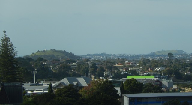
I got there a little early, and while waiting, I took this photo from the window. The volcanic cone on the left is a typical Auckland scoria cone, and is called Takararo (or Mount Victoria). The cone on the right is rather further away and forms the northern edge of the entry to the Waitemata Harbour. A scoria cone on top of a tuff ring volcano, it is called Maungauika (or North Head).
These are two of the volcanoes for my series. Some brief information about them is given below.
Takarunga (Mount Victoria)
Takarunga is 66 m high, and dominates Devonport. The cone was formed by fire-fountaining of frothy scoria. There is a central crater. Lava flowed out from the southern base of the growing volcano; a fan of rocky basalt flows are found between the mountain and the Devonport foreshore.
Takarunga means ‘the hill standing above’, referring to its height above the adjacent Takararo (Mount Cumbria), which has now been almost completely remove through quarrying. It was the site of an important Maori Pa (fortified village); earthworks remain visible.
Its strategic importance was recognised in 1841 with the establishment there of the signal station for the port of Auckland. It has been a public reserve since 1880, although a muzzle-loader fort was constructed on the summit in 1885, and military use continued until the late 1940s.
Maungauika (North Head)
Maungauika (the mountain of Uika) is the traditional name of what is now known as North Head. Named after an ancestor who occupied it 800 years ago, it was weakly terraced by pre-European Maori. It s the eroded remains of a scoria cone overlying a small tuff cone. It began life with a series of wet explosive eruptions followed by drier eruptions of scoria. Together the ash and scoria built a small tuff cone around a central crater, which was later completely filled and buried by the present scoria cone.
The cone’s strategic location made it an important coastal defence site from early in the British colonisation of New Zealand (Aotearoa). In 1885 fears of a Russian invasion of the Pacific led to the construction of a muzzle-loader fort in 1885, and three 8-inch disappearing batteries a year later. Between 1888 and 1914 some of the buildings on Maungauika were occupied by prisoners who excavated many of the tunnels which are still present. The defences were further developed during the Second World War.
Most of the cone became a scenic reserve in 1972. The Defence Forces finally left in the 1990s. It is possible to explore the tunnels built in the late 19th early 20th centuries for defence purposes.
Comments
Sign in or get an account to comment.


