
Clearing ground
A sunny day for once and Cathleen and I spent it clearing ground up by the ruin next to our house .
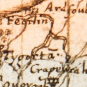
It is what remains of the township shown on the Pont map of the area dating from the last part of the 16th century and named as Feorlin. I have included a screen grab of a detail of that map as my extra photo thanks to the excellent searchable database of the Pont maps on the National Library of Scotland website.
When we first came to the house the walls were in use as a sheep fank but over 25 years it has become covered in small trees, gorse and brambles. Now we are pushing the vegetation back a little in preparation for further improvements later in the summer.
After six hours our backs are a little sore and our arms lacerated by thorns - but it was good to be outside and working.
Comments
Sign in or get an account to comment.


