
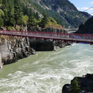
Thompson River, Near Cache Creek
Travelled the Fraser Canyon on Highway 1, the TransCanada Highway today. We left Raymas and Nalla's place around 9.30, did a little shopping in the local store and had coffee (of course) then set off on the first long leg of the trip to Calgary.
Travelling the Fraser Canyon was a first for me, having done the return route between Vancouver and Calgary on 4 previous occasions either via the Okanagan or on the Couquihalla Highway. It was a fantastic journey, beginning in the Fraser Valley which is a broad, flat, fertile and intensively farmed area which abruptly became the Fraser Canyon at Hope and from then on we were in the mountains all the way to Kamloops.
The Fraser is a mighty river, deep, tumultuous and fast flowing, for many miles flanked by steep sided mountains clothed in masses of coniferous trees penetrated by slabs and precipices of bare, shattered rock. This is the Coastal Range, one of the many ranges that form the mountains of British Colombia and Western Alberta. Although this vast mass of mountain are generically referred to as the "Rockies" the Rockies are just one of many ranges that mass together fold on fold running broadly north to south.
As we travelled north and eventually east along the TransCanada the natural environment changed from the wet, green coastal ranges to dry, brown desert like internal mountains in the rain shadow of the coastal ranges. The last leg to Kamloops was through the Thompson - Nicola Desert. These desert areas reminded me of a similar environment east of San Diego and indeed the dry arid lands around Cache Creek and Kamloops and beyond are the northern tip of a long desert that begins in Mexico as the Sonora desert.
To a an enthusiast like myself, the railways of BC and Western Alberta are a source of great fascination. Two lines hugged opposite sides of the Fraser Canyon, which echoed to the sound not just of roaring water but also the grind of several locomotives hauling immensely long trains up steep and winding gradients. For much of the remainder of the journey the TransCanada and the railway are close companions, making use of the same passes to forge a way through the various mountain ranges although nowadays lines disappear into base tunnels rather than struggle over the surface passes. When these lines were first opened the long trains that had crossed the Prairies used to be divided into several smaller portions to be lifted over the passes such was the ferocity of the gradients.
We stopped a few times on the road; most spectacularly at Hell's Gate; the narrowest part of the Canyon, walking down to the river and taking the aerial tramway back up to the road. Even today, at the end of a hot dry summer the water here was 125 feet deep, which is a mere trickle compared with the level of 250 feet achieved in May 1948.
The last few miles of the journey were the most fraught, the sat nav took us down the wrong road for tonight's RV site with the result that it took us over an hour longer than we anticipated, arriving in the late dusk and having to do all the connections by the light of a torch. We will be eager to see what the outlook is in the morning. We are promised a wonderful sunrise tomorrow - around 6.50am - if we're up to see it.
Comments
Sign in or get an account to comment.


