A Bridge and a Mill
The River Petteril
(Part 18)
We are now heading north with the Petteril, and following it as it runs through various villages and hamlets on its way to Carlisle. Looking at the map, it is quite striking how the river is accompanied, virtually all the way, by other means of communication. To the east is the A6, the main road between Penrith and Carlisle, and which was at this point built almost exactly on top of the Roman Road. To the west of the river is the railway and very close to that is the M6. Then there are the minor roads joining up the villages and hamlets and often dissected by the motorway. This particular area was used extensively by the Romans. They built the large fort and civilian centre of Voreda close by and there is evidence of several marching camps, which is not surprising as we are in the vicinity of one of the most important Roman roads north.
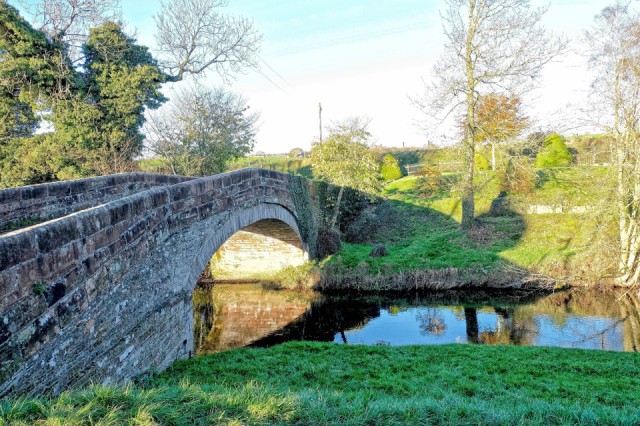
Today we explored Plumptonfoot. It didn’t take long as it is only a hamlet made up of a few farms, but the Petterill runs through it and there is another nice bridge. Here you can see the river and the bridge. On the opposite bank is Plumptonfoot Mill. Well, that’s what it is called, but there is no mill now. There was a Corn Mill here and you can see some of the stone banking where it once was. A guy from the farm at this side of the bridge told us what was there once upon a time and how it has gradually got washed away by the river.
Although we couldn’t see it, there is a channel from the Petteril marked on the map, which obviously supplied the water for the mill. We were also interested to find that there seems to be a number of footpaths marked. Although most appear to be overgrown, boggy, through muddy fields or banks of the river and very little used now, these footpaths all converge at the Mill, just here. It is not difficult to imagine how this bridge became a community gathering place, as people brought corn and collected flour from the mill.
Comments
Sign in or get an account to comment.


