
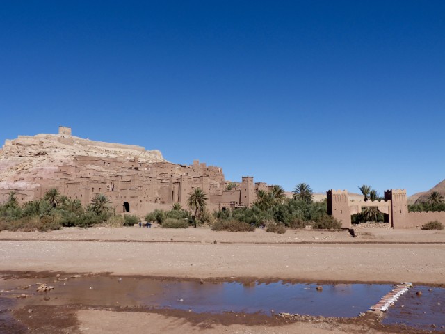
Aït Ben Haddou
The first part of the day was busy. I went to pick up my rented car about 9:30 - a brisk 30 minute walk over to the other side of town. Then I had to find my way safely back to the riad on the wrong (right) side of the road, also factoring in local driving habits.
Hassan in the rental place taught me my first word in Arabic - “stop” as written on road signs at many junctions. It’s important (obviously) - a 400 Dirham (say £35) on-the-spot fine if you miss one.
There is very little traffic here, so it’s really driver/cyclist/pedestrian/donkey/goat behaviour you have to beware of. All of them are challenging.
I was in the car a lot. I drove about 40km north to see the ksar at Aït Ben Haddou (Blipped) - a UNESCO World Heritage Site. I got lunch outside again there. Tourist prices - more than I paid yesterday and only half as good.
Then I drove further on up the Ounila valley towards Telouet. The valley was the main trade route between Marrakech and sub-Saharan Africa. My wee Clio started to act funny around 6,000ft (or it might have been me), so I decided to turn back.
The scenery was stunning all the way. I’ve never been in a desert before and when you combine the desert with the foothills of the High Atlas mountains... it’s just wow.
I haven't been south of the Atlas before, and my memories of Marrakech (north of the mountains) is that the countryside is arid but "only" semi desert. On this side it really is amazing. Dry. Very empty. Stunning geology.
On the other hand, the Ounila valley is irrigated by the river (not much more than a stream, really) and is populated. In turn the people use the water for irrigation, so the very narrow bottom of the valley is vegetated and cultivated. Winter is probably the green season of course, and I suspect it will look quite different 6 months from now.
Comments
Sign in or get an account to comment.


