
Great Polish map of Scotland
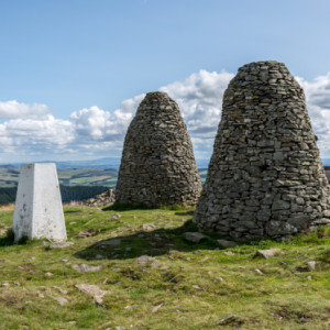
It was S’s birthday and we went down to near Innerleithen to have a walk up the Three Brethren, three impressive cairns marking the meeting of three estates – Buccleuch Estate, Yair Estate and Selkirk Burgh. The extra shows them, the trig point and the Eildon Hills. We then had afternoon tea in Innerleithen before going to see the Great Polish Map of Scotland in the grounds of Barony Castle hotel. It is a large (50 m x 40 m) three-dimensional, outdoor concrete scale model of Scotland, the brainchild of Polish war veteran Jan Tomasik, built between 1974 and 1979 and is claimed to be the world's largest terrain relief model. It is difficult to get a good view and the blip is a panorama from 4 wide angle photos, so it is a little distorted. There are some repairs going on so the water is not present.
Comments
Sign in or get an account to comment.


