Maungakiekie
Maungakiekie is one of Auckland's best known volcanic cones. Also known as One Tree Hill, which it was named because of a single tree which grew on the top of the cone in the 1840s. Maori regarded the summit as the most sacred aspect of the development; their term for it is tihi. This tihi was named Te Totara i Ahua, after the sacred lone totara tree which grew there until "Pakeha vandals" felled it in 1852.
The volcanic cone (and its slopes) was bought from Maori by Thomas Henry in 1845, and he developed a 400 hectare Mt Prospect Estate. However, Governor Grey disallowed the sale and purchase of the summit and the southwestern slopes, which included two breached craters. This land was set aside in 1848 as a public reserve known as One Tree Hill Domain. In 1853 Sir John Logan Campbell and William Brown purchased the remainder of Henry's estate in 1853, and Campbell owned the whole estate by 1873. In 1901 Campbell gifted the land (which he named Cornwall Park in honour of the visit by the Duke and Duchess of Cornwall) to the people of New Zealand.
Campbell began planting the land in the 1860s. There is an olive grove on the northwestern slopes, and a group of Monterey pines were planted at the summit of the cone. Only one survived, until it was felled after being attacked in a protest action by a Maori activist in 2000. No tree has survived on the summit since then.
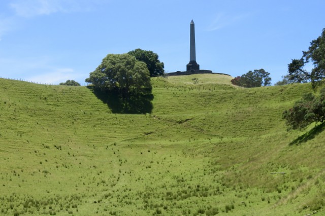
Campbell died in 1912, and he was buried on the summit of Maungakiekie. The 21m high basalt and Coromandel granite obelisk was bequeathed by Campbell as a memorial to the Maori of 1840. The obelisk was not finished until 1948, when it was unveiled by the then Maori King, Koroki.
Maungakiekie was one of the first volcanoes to erupt in the Auckland field. It is also one of the largest, with about 20 square kilometres of lava flow spread around the cone. Much has been pierced by later eruptions, and some has been covered by more recent lava flows.
Maungakiekie (which translates as "the Hill of the Kiekie vine") is the most extensively terraced of all Auckland's cones. It was at the centre of Nga Mara o Tahuri (the gardens of Tahuri). Tahuri was one of the women ancestors of the Waiohua iwi, who had extensive plantings and building comprising one of the largest pre-iron-age forts in the world.
I took this photo at the western end of the long crater. Maungakiekie has three craters. One is intact with a circular caldera. It is behind the trees to the left of the summit. This long crater lost its western rim during the explosions, and the other oval crater to the right of the summit also lost its downhill crater rim to massive explosions during the volcano's active phase.
Comments
Sign in or get an account to comment.


