
Mud, Ruts and a Sunrise
After the last couple of days, it was a pleasure, despite the keen wind, to walk out just before sunrise under predominantly clear skies. After yesterday's evidence of the rising rivers near Stafford, I wondered what conditions would be like in the fields near home.
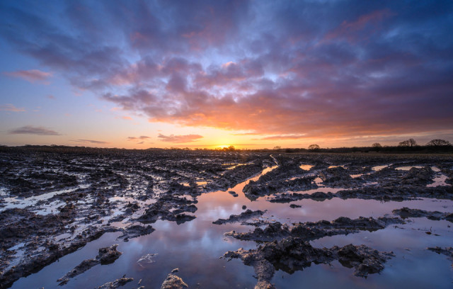
This is by a gate entering into this field. When I last spoke to the farmer he was bemoaning the conditions, which had prevented him from being able to sow a winter crop. The evidence of last year's corn crop can still just be seen in the distance. This whole area in the foreground is flooded, despite no local watercourse nearby.*
I was surprised to get this image. Only a few minutes before the sky only had a few wisps of cloud near the horizon, but then this large bank of cloud imposed itself from the south west, just as the sun rose.
*It was only as I was adding the location to the map that it showed that the course of Wash Brook passed only a few feet from where I was standing. If you check and switch between the satellite and map layers you will see there is no evidence at all of the brook on the image. I can only assume it has been diverted or culverted in this area. The brook Issues from land only a few hundred yards further east.
Day Miles: 2.2 miles Total Miles: 232.3 miles
Comments
Sign in or get an account to comment.


