
Observing our landscape
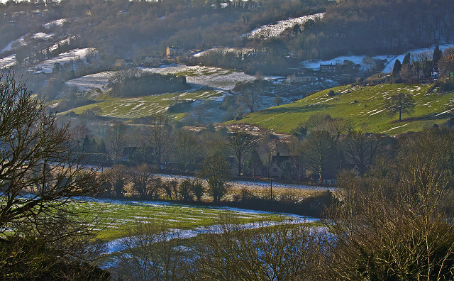
The heavy rain last night had passed over by this morning and the sun was shining on the thawing snow clad landscape when I got up today. The sun's trajectory is still quite low in the sky, so that its early morning rays are nearly parallel to the land surface. I could see some normally hidden details being revealed by the warming sunshine wherever the thicker snow is nestled in low lying situations.
I am interested in landscape history and I knew that I needed to be taking pictures of these features for my archive, before the thaw went much further, so I can look back and compare the views with details on old maps.
At the top of the picture you can just see the sky behind the trees on the top of Rodborough Common, which was occupied in the Iron Age. This Golden Valley was formed by the River Frome cutting down through the various underlying layers, or strata, of the Cotswold limestone formations interspersed with various clay bands. At the bottom of the far slope lies the canal, the visible railway lines and the main road. Springs emerge along the springline and ones with larger flows form streams, which cut new valleys at right angles to the main river.
In ancient times the only way for people to move easily along the valley was to follow the highest spring lines which are marked in the picture by the line of houses and farm buildings running along the far side of the main valley. The woodlands tend to be above the water line and below are meadows and fields where there was better soil. At the upper right edge of the picture are the last houses of Butterow, before the road follows the side valley, or combe, which is named Montserrat, with the lane changing its name to Bagpath Lane as it moves eastwards.
In the closest foreground are the trees on the slope of the Lime Brook, which runs down behind our house also at right angles to the river Frome, which it joins at Bowbridge, about three hundred yards away to the right of the picture. On the far side of the Lime Brook there are many straight white lines of snow, with a particularly wide one at right angles to the many smaller ones, which is line of the ancient Wey, an old and disused cross country route way leading from one hilltop to another, then on along the line of the Cotswold hills.
The white lines show up the remnants of the ridge and furrow open field system, with the snow lying in the furrows or troughs. They have very regular patterns formed by the use of cows for ploughing, and at each end there is a headland where the animals had to turn in a wide curve. I knew about the nearest ridge and furrows as you can actually just about see them with the naked eye at certain times of the year depending on the state of its vegetation. But the combination of the lying snow and the low level sunlight makes them appear much more clearly.
So I was really pleased to see some other ridge and furrow formations for the first time this morning, on the far side of the valley below Montserrat. You can just see the lines running down the meadows towards the railway line. I've also noticed in my pictures some distinctive tracks or footpaths being exposed like this too, which I can compare with those on maps. They help to pick out the shapes of the field systems of former times, from long before this valley became such a distinguished centre of the woollen industry, with it abundance of mills. I also know that my friend Neil, a local archaeologist, has discovered roman pottery very close to the foreground of this picture, so we surmise that it has been occupied ever since then, even if only intermittently.
The houses in the middle of this picture are late twentieth century homes built out of town on another old lane that leads up the springline on this side of the River Frome, where houses have always been sited close to water and the paths which are not waterlogged. Between them and the nearest ridge and furrow is a field which was formerly an apple orchard according to the 1842 Tithe map. Its hedgerow is also ancient, and marks the line of an early footpath, one of the many that are found all over these hills and vales.
Sadly, that same very old orchard is now the target of housing developers, who are targeting at least three similar sites in this Area of Outstanding Natural Beauty (AONB). They want to build hundreds of new homes, which I admit are needed, but we (the council, and many local residents) say they should be using the brownfield sites of obsolete former industrial buildings. The next door Slad valley is also under a similar threat. There are some fights ahead, starting on Tuesday, when one of the developers present there proposals at a public meeting, for a site half a mile to right of this picture, on a bit of land like the ridge and furrow I've just discovered here.
Comments
Sign in or get an account to comment.


