Hurley Tunnel
Backblipped for 20.8.21
I apologise for the long delay in posting this Blip. In the creation of the text not only was there an exhaustive, time-consuming and failed search through Blipfoto for my own Blips in order to add the links, but a trawl through our own photo files and the subsequent realisation that relevant photos were missing. Possibly these will turn up in some unrelated file but fortunately I still had the original memory card containing all that day's photos, not just those Blipped. This denoument revealed the date of the Blips and the discovery that I had not actually named the item for which I was searching; neither had I mentioned later the follow-up in question - small wonder I could not find these on any Blip search no matter how many key words used! It was quite late by then so I gave up and, next morning, edited the original blip and added tags, so should prove more accessible it the future.
Our adventure began way back on 26.11.19 when, having discovered the existence of the Hurley (or Harlaw) Tunnel, we paid a visit to the entrance. Subsequently, on a visit on 8.1.20 we tried to find that other end but, close as we calculated we were, the path (such as it was) petered out. We did think we saw some form of stone structure in the near distance, hidden in trees. In any case, the entrance seemed to be high above ground and, the most important factor, the River North Esk, into which we were in danger of slipping. The previous day had been extremely windy and wet, the river now running high and we resolved to return on the opposite bank but in better weather.
Those photos were not worthy of a Blip and another subject won out but today was the day chosen to complete the quest. On the map it appeared so straightforward, a path appeared to exist across the desired area, all we needed to do was cut across to the river at an appropriate point and peer into the opposite bank. But we had overlooked a few important factors: how to access the area from the main path; the terrain, which was not level or gently sloping but undulating in a series of steep rows; the absence of a satellite signal to indicate just where we were; the vegetation, which at the more level area proved the most difficult to overcome, being thick bracken, sometimes at chest height, and clumpy reeds; and the trees on the opposite bank, still in leaf, obscuring whatever view we might have. What idiots we were, why did we not wait until leaf fall and the dropping of the vegetation? Nothing daunted, we ploughed on.
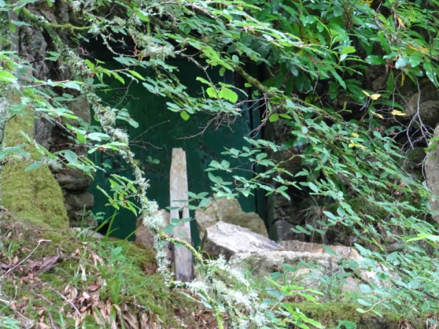
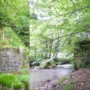
But see! We did indeed find the entrance, clearly enough to recognise it as such and the graffitti upon it (this is Mr Flum's photo, he has manual focus). In Extra 1 the stonework abutment and its companion on our side of the river, which, when the tunnel (seen in the greenery above) was in use, supported a bridge over the river. To cap it all, we later realised that the abutments on both sides of the river are visible in photographs taken on our previous attempt, but which were unrecognisable as such.
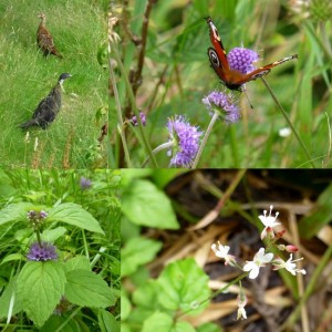
So, mixed results but the day was not entirely wasted (despite the disappointment that the cafe was closed): on the way we discovered a pheasant farm and part of our path was accompanied by immature birds, a patch of Corn Mint (Mentha arvensis), delightful pretty flowers of Enchanter's Nightshade (Circaea lutetiana) growing among the bracken and reeds near the river, a Peacock butterfly feeding on Devil'sbit Scabious (Succisa pratensis), all in Extra 2; we encountered tiny froglets, noted (from the terrace) a pair of swans on the low pond.
To conclude: an interesting expedition and, if in need of a thorough workout, just try a search for something found on a map!
Comments
Sign in or get an account to comment.


