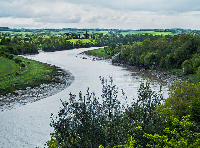
The Horseshoe Bend.
The sweeping left hand bend in the River Avon, shown here, is but half of the Horseshoe Bend. The panoramic shots on the internet showing the full extent of it would require mountaineering skills and courage beyond my capabilities.
The River Severn, into which the Avon flows, reputedly has the second highest tide in the world at 48 feet, this is reflected in the tidal range here with the salt marshes on the opposite bank being flooded at high tide while, at low tide, the waterway is both narrow and shallow; hidden beneath the brown mud of the banks, the various rock types that dominate the geology of the area are a major hazard.
Large cargo ships used to navigate this stretch of water to Bristol Docks, and timing was crucial; the five miles from Avonmouth to Bristol had to be run with the rising tide to dock in Bristol at high tide - otherwise you wouldn't make it. The reverse journey had to be run just after high tide to clear the Horseshoe before the water level dropped too much and, I guess, you didn't want to meet another vessel coming the other way.
Many didn't make it, the most famous being the 300 foot German cargo ship, the Kron Prinz; on April Fools' Day, 1874, she ran aground just beneath the cliff on which I stood for this blip; I imagine both both ends grounded on the near bank and there she stuck. As the tide went out she toppled over, spilling her cargo of grain, and suffering the ignominy of having her masts sawn off to keep the waterway open.
It was not until April the twentieth that she was refloated and towed to Bristol for repairs costing £34,000.
In the meantime, a temporary railway station was opened for tourists to come and watch the salvage operations.
Comments
Sign in or get an account to comment.


