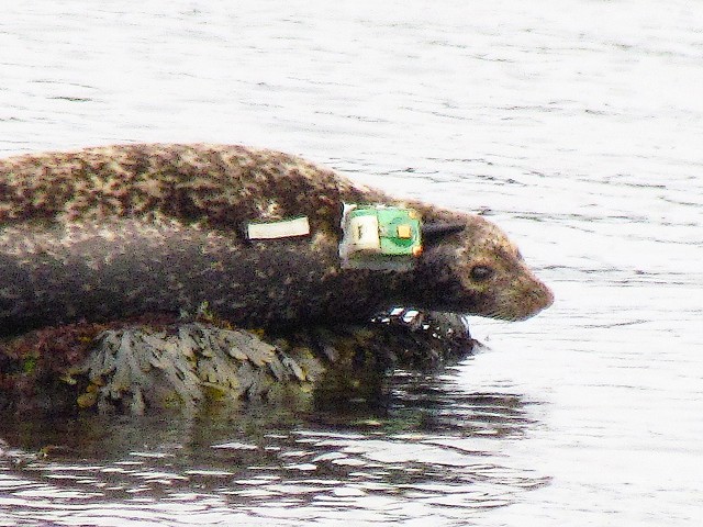
Satellite Tracked Harbour Seal
I spotted this satellite tagged harbour seal (Phoca vitulina) on rocks offshore this afternoon. It was about half way between Kirkcaldy and Kinghorn, Fife.
My camera was on full optical zoom (840mm equiv) plus full digital zoom (4X) so the image isn't the best of quality. However, I decided to blip it for its interest value.
It looks as if there was once a second unit stuck further back from the obvious one. The visible one has a large battery and sensors that measure wet/dry, temperature, and depth. These, along with GPS satellite location data are phoned back to a base.
The purpose of such tracking serves many purposes. It helps identify which areas are important to the seals for food foraging helping to avoid conflict with commercial fishing interests or oil-industry activities. There has also been a recent decline in their population so the data may shed some light on the reasons.
Since harbour seals are not known for travelling long distances (unlike grey seals), I suspect this one was tagged not far away and so is probably one being monitored by the Sea Mammal Research Unit (SMRU) of St. Andrews University.
[EDIT 19th June 2013]
I went back today and saw THREE seals similarly tagged so it looks like someone is intensively studying this group.
ALTERNATIVE INTERPRETATIONS (if you believe conspiracy theories)
==========================
1) It is a 'Navy Seal' trained to dive beneath enemy vessels and eavesdrop on their communications.
2) It is the latest weapon in the fight against sub-marine aliens, radio-controlled by ufologists.
3) It is a yuppie seal sporting the latest must-have accessory - a mobile phone.
4) 'Garmin' (marine satnav) for seals.
Comments
Sign in or get an account to comment.


