The Puggy Line
Well it has been really hot today.
The dogs got a wee stretch with some cooling swims at a relatively shady Achaderry. After that they seemed happy enough to lounge about in the shade in the garden. By way of some further exploration (for future dog walks) I took a very short jaunt on the bike.
I went back in to the village on the A86, and found some stepping stones which cross the river Spean just above the confluence with the River Roy. I was told about them ages ago and it is only today I have used them.
The south side of the river has an entirely different feel to the village side. After crossing the stones I continued on a well made, if very rough track, east ward toward an area known as Monessie.
Anyone who has driven on the A86 east of Roy Bridge can not have failed to notice a vast bing of quarried material perched on the glen's south slope here. It a 90 year old stockpile which is actually arisings from the tunnel excavation which links Loch Treig Reservoir with the Alcan power house in Fort William. It is 15 miles long and was excavated on 13 faces accessed from various addits along the alignment. The addits are horizontal (actually inclined slightly up) tunnels in to the mountain from which the tunnel was excavated left and right from their terminations. Also notable, though now uplifted, was the "Puggy Line". This was a narrow gauge railway built to aid construction and then sevice the new scheme one it was up and running. It follows well engineered geometry and had countless structures to span hill burn gorges. These bridges are mostly dilapidated now but are still prominent.
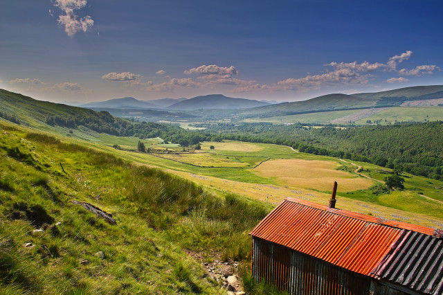
I climbed up the side of the bing and then higher to the old railway. This shed must have been a welfare cabin or workshop but now seems to be an informal shelter for livestock. It was very smelly as I approached it and then a dozen black face ewes scampered out as I passed it. I didn't intend to disturb them and they were obviously taking shade from the sun.
It is a fine view point and this is a view west down Glen Spean. If you go large you can make out some of Roy Bridge. While it is not apparent from this angle the large panel of lay by shaped yellow grass above the shed ridge line is the landscaped flat top of the rock bing. You may just make out my bike. There are several tens of thousands of tons of rock here which originated from within the mountain. Other similar bings are visible along the 15 mile route.
I had thought of some sort of circular route following the old puggy line but it is not even easy to walk on as there is still bits of overgrown old sleeper and rail. Given the intense heat this is probably just as well and I returned the way I had aproached.
Comments
Sign in or get an account to comment.


